
Bracken Hall Countryside Centre
Bracken Hall Countryside Centre is a children's museum, natural history museum, local archaeology museum, interpretation centre. On the map, it sits 200 m west of Baildon. Top of the 52 other places within 15 km is National Science and Media Museum, 7 km off.
Museum near Baildon
Just outside Baildon
Bracken Hall Countryside Centre is 200 m west of Baildon. Towns near it ↓
Written from OpenStreetMap, Wikidata, the ONS built-up areas and Met Office 1991–2020 averages.
How the seasons run
Afternoons in Baildon peak at 18–20°C, June to August.
Bracken Hall Countryside Centre
Readers can find it on Wikipedia in 2 languages.
- Type
- Museum
- Wikipedias
- Covered in 2 languages
- Town
- 200 m west of Baildon
- Official site
- bradfordmuseums.org/brackenhall/index.htm
Map of Bracken Hall Countryside Centre and nearby
Each numbered point is one of the places listed below; Bracken Hall Countryside Centre is the orange one.
© OpenStreetMap contributors · ONS built-up area 2022
Which town is nearest
Bradford is the biggest of the 8 bases nearby (333,968 people). Each of these towns lists it on its own page of things to do.
Baildon
Bingley
Shipley
Bradford
Compare the 8 towns
| Town | Where Bracken Hall Countryside Centre is | People | Places to visit |
|---|---|---|---|
| Baildon | 200 m east of it | 17,056 | 15 |
| Bingley | 600 m west of it | 21,334 | 14 |
| Shipley | 900 m southeast of it | 29,228 | 19 |
| Bradford | 2.9 km southeast of it | 333,968 | 34 |
| Keighley | 4 km west of it | 48,754 | 12 |
| East Morton | 4.1 km northwest of it | 1,227 | 13 |
| Harden | 4.2 km west of it | 1,602 | 13 |
| Wilsden | 4.3 km southwest of it | 3,749 | 12 |
Nearby, too
Within 15 km are 52 places, among them 3 museums, a cathedral and a castle.
 MuseumNational Science and Media Museum7 km away · 442K visitors a year (2015)2
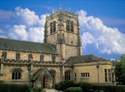 CathedralBradford Cathedral6.8 km away3
 CastleCliffe Castle8 km away · 65K visitors a year4
 Abbey or prioryKirkstall Abbey (Ruins)13 km away5
 MuseumBronte Parsonage Museum10 km away6
 MuseumThe Peace Museum1.3 km away7
 Art galleryCartwright Hall Art Gallery4.4 km away8
 Historic house · National TrustEast Riddlesden Hall6.1 km away
Within 15 km, close and well known first. Numbers match the map.
Visiting Bracken Hall Countryside Centre
Where is Bracken Hall Countryside Centre?
Bracken Hall Countryside Centre is 200 m west of Baildon, West Yorkshire.
What is Bracken Hall Countryside Centre?
Children's museum, natural history museum, local archaeology museum, interpretation centre in West Yorkshire, England.
When is the best time to visit Bracken Hall Countryside Centre?
June to August are the warmest months in Baildon, with afternoon highs of 18–20°C (Met Office 1991–2020 averages).
What else is there to see near Bracken Hall Countryside Centre?
Within 15 km: National Science and Media Museum (7 km), Bradford Cathedral (6.8 km), Cliffe Castle (8 km) and Kirkstall Abbey (Ruins) (13 km).
Places: OpenStreetMap (© OpenStreetMap contributors, Open Database Licence) and Wikidata (CC0), placed in the ONS 2022 built-up area (Open Government Licence v3.0). Visitor counts are the latest Wikidata gives, with their year.
Photos: each place’s Wikidata image, from Wikimedia Commons under the licence below (our copy, resized).
Photo credits (9)
- Bracken Hall Countryside Centre: Linda Spashett Storye book, CC BY 3.0, Wikimedia Commons
- National Science and Media Museum: Chemical Engineer, CC BY-SA 4.0, Wikimedia Commons
- Bradford Cathedral: Mick Melvin, CC BY-SA 2.0, Wikimedia Commons
- Cliffe Castle: Tim Green from Bradford, CC BY 2.0, Wikimedia Commons
- Kirkstall Abbey (Ruins): JohnArmagh, Public domain, Wikimedia Commons
- Bronte Parsonage Museum: SpaceMonkey at en.wikipedia, Public domain, Wikimedia Commons
- The Peace Museum: The wub, CC BY-SA 4.0, Wikimedia Commons
- Cartwright Hall Art Gallery: Flickr user:Tim Green aka atouch, CC BY 2.0, Wikimedia Commons
- East Riddlesden Hall: David Dixon, CC BY-SA 2.0, Wikimedia Commons
Contains public sector information licensed under the Open Government Licence v3.0. Contains HM Land Registry data © Crown copyright and database right 2026. Contains OS data © Crown copyright and database right 2026 (ONS boundaries). Northern Ireland: Source: NISRA; contains Land & Property Services data and Ordnance Survey of Northern Ireland information, © Crown copyright, licensed under the Open Government Licence v3.0. Scotland: contains National Records of Scotland data, Registers of Scotland data and SEPA data, © Crown copyright / © SEPA 2025, licensed under the Open Government Licence v3.0.