Binchester Roman Fort
The site of Binchester Roman Fort, a historic site, is 1 km north of Bishop Auckland. It is run by Durham County Council. Our list has 25 more places within 15 km; first among them is Durham Castle, at 13 km.
Historic site near Bishop Auckland
Just outside Bishop Auckland
Binchester Roman Fort is 1 km north of Bishop Auckland. Towns near it ↓
Written from OpenStreetMap, Wikidata, the ONS built-up areas and Met Office 1991–2020 averages.
Weather, month by month
Expect highs of 17–20°C in Bishop Auckland from June to September.
Binchester Roman Fort
Historic site.
- Type
- Historic site
- Run by
- Durham County Council
- Town
- 1 km north of Bishop Auckland
- Official site
- durham.gov.uk/binchester
Before you set off
- EntryA fee is charged
Getting your bearings
The map centres on Binchester Roman Fort, in orange, with nearby places numbered.
© OpenStreetMap contributors · ONS built-up area 2022
Which towns are near Binchester Roman Fort
Bishop Auckland is the biggest of the 8 bases nearby (23,359 people). They run in order of distance, starting where it stands.
- 1Bishop Auckland
- 2Hunwick
- 3Byers Green
- 4Coundon and Leeholme
- 5Willington
- 6Spennymoor
- 7Witton Park
- 8Eldon Lane and Coundon Grange
Bishop Auckland
Hunwick
Byers Green
Coundon and Leeholme
Compare the 8 towns
| Town | Where Binchester Roman Fort is | People | Places to visit |
|---|---|---|---|
| Bishop Auckland | 1 km south of it | 23,359 | 10 |
| Hunwick | 2.1 km northwest of it | 657 | 8 |
| Byers Green | 2.7 km northeast of it | 829 | 9 |
| Coundon and Leeholme | 2.7 km southeast of it | 2,522 | 9 |
| Willington | 2.9 km north of it | 5,685 | 9 |
| Spennymoor | 3 km northeast of it | 20,401 | 12 |
| Witton Park | 3.2 km west of it | 333 | 8 |
| Eldon Lane and Coundon Grange | 3.4 km southeast of it | 995 | 8 |
More to see nearby
Around it, within 15 km, lie 25 more, including 4 castles, a cathedral and a historic house.
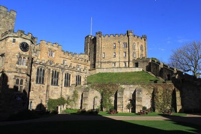 CastleDurham Castle13 km away2
 CathedralDurham Cathedral13 km away3
 Historic house · English HeritageAuckland Castle1.2 km away4
 MuseumLocomotion - The National Railway Museum at Shildon6.5 km away · 94K visitors a year5
 CastleRaby Castle12 km away6
 CastleWitton Castle5.7 km away7Theme parkTheme parkKynren600 m away8
 CastleBrancepeth Castle6.6 km away
Within 15 km, close and well known first. Numbers match the map.
Binchester Roman Fort, answered
Where is Binchester Roman Fort?
Binchester Roman Fort is 1 km north of Bishop Auckland, County Durham.
What is Binchester Roman Fort?
Historic site.
Who runs Binchester Roman Fort?
Durham County Council.
When is the best time to visit Binchester Roman Fort?
June to September are the warmest months in Bishop Auckland, with afternoon highs of 17–20°C (Met Office 1991–2020 averages).
What else is there to see near Binchester Roman Fort?
Within 15 km: Durham Castle (13 km), Durham Cathedral (13 km), Auckland Castle (1.2 km) and Locomotion - The National Railway Museum at Shildon (6.5 km).
Places: OpenStreetMap (© OpenStreetMap contributors, Open Database Licence) and Wikidata (CC0), placed in the ONS 2022 built-up area (Open Government Licence v3.0). Visitor counts are the latest Wikidata gives, with their year.
Photos: each place’s Wikidata image, from Wikimedia Commons under the licence below (our copy, resized).
Photo credits (7)
- Durham Castle: Carla Brain, CC BY-SA 2.0, Wikimedia Commons
- Durham Cathedral: Benjamin Smith, CC BY-SA 4.0, Wikimedia Commons
- Auckland Castle: Pit-yacker, CC BY-SA 3.0, Wikimedia Commons
- Locomotion - The National Railway Museum at Shildon: Hugh Mortimer, CC BY-SA 2.0, Wikimedia Commons
- Raby Castle: malcolm tebbit, CC BY-SA 2.0, Wikimedia Commons
- Witton Castle: Hugh Mortimer, CC BY-SA 2.0, Wikimedia Commons
- Brancepeth Castle: Oliver Dixon, CC BY-SA 2.0, Wikimedia Commons
Contains public sector information licensed under the Open Government Licence v3.0. Contains HM Land Registry data © Crown copyright and database right 2026. Contains OS data © Crown copyright and database right 2026 (ONS boundaries). Northern Ireland: Source: NISRA; contains Land & Property Services data and Ordnance Survey of Northern Ireland information, © Crown copyright, licensed under the Open Government Licence v3.0. Scotland: contains National Records of Scotland data, Registers of Scotland data and SEPA data, © Crown copyright / © SEPA 2025, licensed under the Open Government Licence v3.0.