- Type
- School
- NIAH reg. no.
- 41403404
Carrickashedoge National School
About Carrickashedoge National School
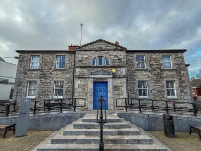
Carrickashedoge National School is one of 83 buildings in Carrickmacross the National Inventory rates Regional. Carrickashedoge National School dates from 1895–1900.
This late nineteenth-century rural national school has an attractively composed elevation to the main road, once symmetrical with male and female entrances, yards and toilets. While it has been recently altered and extended the pared-back simplicity of its main elevation has been retained.
From the National Inventory’s appraisal, record 41403404 · CC BY 4.0 · Department of Housing, Local Government and Heritage
NIAHRead its National Inventory recordThe full description and appraisal, the survey photo and the map · 41403404↗Regional is the National Inventory’s rating for a building of significance in its region; most rated buildings carry it.
Finding Carrickashedoge National School
Carrickmacross


Public buildings on the record near Carrickmacross
All 8 are pictured and within 40 km. The nearest is National Irish Bank in Bailieborough, 17 km away. Farthest out is The Tholsel, Drogheda, 34 km away.




Questions about Carrickashedoge National School
Is Carrickashedoge National School on the National Inventory?
Yes: rated Regional (record 41403404).
Can you visit Carrickashedoge National School?
It can be seen from the street; whether you can go inside depends on its owner.
When was Carrickashedoge National School built?
Its National Inventory record dates it to 1895–1900.
Is Carrickashedoge National School protected?
Being on the National Inventory or the Sites and Monuments Record is a record, not protection by itself: buildings are protected by their council’s Record of Protected Structures, which each council keeps and no national open list gathers, so this page can’t say which are on it.
Source: National Inventory of Architectural Heritage and Sites and Monuments Record, Department of Housing, Local Government and Heritage (CC BY 4.0); Wikidata (CC0).
Sources: National Inventory of Architectural Heritage (buildingsofireland.ie). Under Creative Commons Attribution 4.0 (CC BY 4.0).
Contains Central Statistics Office (CSO) data, Census 2022, and Tailte Éireann boundaries (CSO Urban Areas, Small Areas, local electoral areas, constituencies), under Creative Commons Attribution 4.0 (CC BY 4.0).