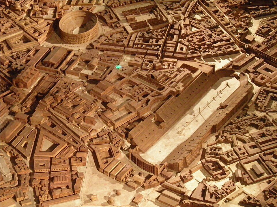
Plan de Rome par Paul Bigot
Plan de Rome par Paul Bigot is a scale models of 4th-century Rome in Brussels and Caen. It lies in Caen itself. Nearby, Château de Caen (600 m) heads a list of 162 within 15 km.
Museum in Caen
One of the best-known places to visit in France
#1,591 of the 37,318 museums, châteaux, gardens and other attractions we list in France, by how widely it is covered (5 Wikipedia and sister-site articles). About ↓
In Caen
Plan de Rome par Paul Bigot is in the commune of Caen, with 62 more places to visit within 5 km. Towns near it ↓
Written from OpenStreetMap, Wikidata and Météo-France 1991–2020 normals.
Seasons in Caen
Expect highs of 17–23°C in Caen from May to September.
Plan de Rome par Paul Bigot
Articles on it exist in 5 languages.
- Type
- Museum
- Covered in
- 5 Wikipedia and sister-site articles
- Commune
- Caen, Calvados
- Official site
- rome.unicaen.fr
Plan de Rome par Paul Bigot on the map
The places near Plan de Rome par Paul Bigot are numbered on the map in the order below.
© OpenStreetMap contributors · The dashed line is the commune of Caen. · commune boundary: IGN
Towns that list Plan de Rome par Paul Bigot
The biggest base of the 8 is Caen (109,400 people). Its own town leads; the rest list it too, closest first.
- 1Caen
- 2Hérouville-Saint-Clair
- 3Mondeville
- 4Bretteville-sur-Odon
- 5Cormelles-le-Royal
- 6Louvigny
- 7Fleury-sur-Orne
- 8Colombelles
Caen
Hérouville-Saint-Clair
Mondeville
Bretteville-sur-Odon
Compare the 8 towns
| Town | Where Plan de Rome par Paul Bigot is | People |
|---|---|---|
| Caen | It’s in this commune | 109,400 |
| Hérouville-Saint-Clair | 2.6 km northeast of it | 23,470 |
| Mondeville | 4 km southeast of it | 10,331 |
| Bretteville-sur-Odon | 4.4 km southwest of it | 4,494 |
| Cormelles-le-Royal | 4.4 km southeast of it | 5,377 |
| Louvigny | 4.5 km southwest of it | 2,612 |
| Fleury-sur-Orne | 4.6 km south of it | 5,941 |
| Colombelles | 5 km east of it | 7,243 |
Combine it with these
Of the 162 within 15 km, look for 3 museums, a château and a monastery.
 ChâteauChâteau de Caen600 m south, in Caen2Monastery or conventMonastery or conventAbbaye Royale aux Hommes1.3 km southwest, in Caen3AbbeyAbbeyAbbaye aux Dames de Caen1.1 km southeast, in Caen4MuseumMuseumMémorial de Caen1.5 km northwest, in Caen5
 MuseumMusée des Beaux-Arts de Caen700 m southeast, in Caen6
 MuseumMusée de Normandie700 m south, in Caen7GardenGardenJardin des plantes de Caen500 m southwest, in Caen8AttractionAttractionAbbaye d'Ardenne3.5 km west, in Saint-Germain-la-Blanche-Herbe
Within 15 km, close and well known first. Numbers match the map.
Visiting Plan de Rome par Paul Bigot: the answers
Where is Plan de Rome par Paul Bigot?
Plan de Rome par Paul Bigot is in Caen, in Calvados (Normandy).
What is Plan de Rome par Paul Bigot?
Scale models of 4th-century Rome in Brussels and Caen.
How well known is Plan de Rome par Paul Bigot?
Plan de Rome par Paul Bigot has 5 Wikipedia and sister-site articles in different languages: #1,591 of the 37,318 French places we list.
When is the best time to visit Plan de Rome par Paul Bigot?
May to September are the warmest months in Caen, with afternoon highs of 17–23°C (Météo-France 1991–2020 normals).
What else is there to see near Plan de Rome par Paul Bigot?
Within 15 km: Château de Caen (600 m), Abbaye Royale aux Hommes (1.3 km), Abbaye aux Dames de Caen (1.1 km) and Mémorial de Caen (1.5 km).
Sources: OpenStreetMap (© OpenStreetMap contributors, ODbL), Wikidata (CC0: what it is, its articles, how widely it is covered), the Culture ministry’s Mérimée database (Licence Ouverte 2.0), IGN commune boundaries, Météo-France 1991–2020 normals (Licence Ouverte 2.0).
Photos from Wikimedia Commons, each under its own licence (our copy, resized).
Photo credits (4)
- Plan de Rome par Paul Bigot: Pascal Radigue, CC BY-SA 3.0, Wikimedia Commons
- Château de Caen: Nikater, Public domain, Wikimedia Commons
- Musée des Beaux-Arts de Caen: Own work, CC BY-SA 3.0, Wikimedia Commons
- Musée de Normandie: Karldupart, CC BY-SA 4.0, Wikimedia Commons
Contains public sector information under the Licence Ouverte / Open Licence 2.0 (Etalab): INSEE, DGFiP, the Interior Ministry’s statistics service (SSMSI), the Ministry of Education (DEPP), the Health Ministry’s statistics service (DREES) and the Housing Ministry (Carte des loyers). Commune boundaries: IGN Admin Express.