
Parc animalier de Merlet
Set in Les Houches, Parc animalier de Merlet is a zoo. Its neighbours on our list number 15 within 5 km. The pick nearby is Aiguille du Midi, 6.2 km off.
Zoo in Les Houches
One of the best-known places to visit in France
#3,165 of the 37,318 museums, châteaux, gardens and other attractions we list in France, by how widely it is covered (3 Wikipedia and sister-site articles). About ↓
In Les Houches
Parc animalier de Merlet is in the commune of Les Houches, with 15 more places to visit within 5 km. Towns near it ↓
Written from OpenStreetMap, Wikidata and Météo-France 1991–2020 normals.
The best months to visit
Aim for May to September, when Les Houches reaches 18–24°C.
Parc animalier de Merlet
Readers can find it on Wikipedia in 3 languages.
- Type
- Zoo
- Covered in
- 3 Wikipedia and sister-site articles
- Commune
- Les Houches, Haute-Savoie
- Official site
- parcdemerlet.com
Useful details
- EntryA fee is charged
Where Parc animalier de Merlet is
The orange dot is Parc animalier de Merlet; the numbers are the places near it, as listed below.
© OpenStreetMap contributors · The dashed line is the commune of Les Houches. · commune boundary: IGN
Towns that list Parc animalier de Merlet
Among the 7, Sallanches is the biggest, home to 17,319 people. The town it is in comes first, then the others whose pages list it, nearest first.
Les Houches
Chamonix-Mont-Blanc
Saint-Gervais-les-Bains
Passy
Compare the 7 towns
| Town | Where Parc animalier de Merlet is | People |
|---|---|---|
| Les Houches | It’s in this commune | 3,515 |
| Chamonix-Mont-Blanc | 4.6 km northeast of it | 8,705 |
| Saint-Gervais-les-Bains | 8.7 km west of it | 5,755 |
| Passy | 9 km west of it | 10,856 |
| Sallanches | 15 km west of it | 17,319 |
| Megève | 17 km west of it | 2,893 |
| Magland | 19 km northwest of it | 3,220 |
More to see nearby
Within 15 km are 53 places, among them 6 attractions and 2 museums.
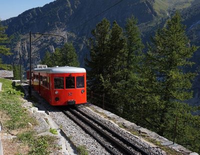 MuseumChemin de fer du Montenvers4.7 km east, in Chamonix-Mont-Blanc4
 MuseumTramway du Mont-Blanc8.4 km west, in Saint-Gervais-les-Bains5
 AttractionCompagnie des guides de Chamonix2.4 km east, in Chamonix-Mont-Blanc6AttractionAttractionPlanpraz4.3 km northeast, in Chamonix-Mont-Blanc7AttractionAttractionMontenvers8.2 km east, in Chamonix-Mont-Blanc8
 AttractionGrotte de glace de la Mer de Glace8.3 km east, in Chamonix-Mont-Blanc
Within 15 km, close and well known first. Numbers match the map.
Quick answers on Parc animalier de Merlet
Where is Parc animalier de Merlet?
Parc animalier de Merlet is in Les Houches, in Haute-Savoie (Auvergne-Rhône-Alpes).
What is Parc animalier de Merlet?
Zoo.
How well known is Parc animalier de Merlet?
Parc animalier de Merlet has 3 Wikipedia and sister-site articles in different languages: #3,165 of the 37,318 French places we list.
When is the best time to visit Parc animalier de Merlet?
May to September are the warmest months in Les Houches, with afternoon highs of 18–24°C (Météo-France 1991–2020 normals).
What else is there to see near Parc animalier de Merlet?
Within 15 km: Aiguille du Midi (6.2 km), Le Brévent (3.3 km), Chemin de fer du Montenvers (4.7 km) and Tramway du Mont-Blanc (8.4 km).
Sources: OpenStreetMap (© OpenStreetMap contributors, ODbL), Wikidata (CC0: what it is, its articles, how widely it is covered), the Culture ministry’s Mérimée database (Licence Ouverte 2.0), IGN commune boundaries, Météo-France 1991–2020 normals (Licence Ouverte 2.0).
Photos from Wikimedia Commons, each under its own licence (our copy, resized).
Photo credits (5)
- Parc animalier de Merlet: Rémih, CC BY-SA 4.0, Wikimedia Commons
- Chemin de fer du Montenvers: Tiia Monto, CC BY-SA 3.0, Wikimedia Commons
- Tramway du Mont-Blanc: Florian Pépellin, CC BY-SA 4.0, Wikimedia Commons
- Compagnie des guides de Chamonix: Calips, CC BY-SA 3.0, Wikimedia Commons
- Grotte de glace de la Mer de Glace: Tiia Monto, CC BY-SA 3.0, Wikimedia Commons
Contains public sector information under the Licence Ouverte / Open Licence 2.0 (Etalab): INSEE, DGFiP, the Interior Ministry’s statistics service (SSMSI), the Ministry of Education (DEPP), the Health Ministry’s statistics service (DREES) and the Housing Ministry (Carte des loyers). Commune boundaries: IGN Admin Express.