Omart
Set in Lyon 2e is Omart. Its neighbours on our list number 202 within 5 km. First among the places near it is Primatiale Saint-Jean de Lyon, at 300 m.
Art gallery in Lyon 2e
In Lyon 2e
Omart is in the commune of Lyon 2e, with 202 more places to visit within 5 km. Towns near it ↓
Written from OpenStreetMap, Wikidata and Météo-France 1991–2020 normals.
Weather by the month
April to October are the warmest in Lyon 2e, with afternoon highs of 17–28°C.
Omart
Art gallery.
Omart is in Lyon 2e, Rhône.
- Type
- Art gallery
- Commune
- Lyon 2e, Rhône
- Official site
- omart.fr
Before you set off
Around Omart, mapped
On this map, Omart is orange and its neighbours are numbered.
© OpenStreetMap contributors · The dashed line is the commune of Lyon 2e. · commune boundary: IGN
Towns close to Omart
By population, Lyon 3e leads the 8 with 100,679. These are the towns that list it, beginning with its own.
Lyon 2e
Lyon 1er
Lyon 6e
Lyon 7e
Compare the 8 towns
What else is near Omart
Choose from 359 places within 15 km, such as 4 attractions, 3 museums and a garden.
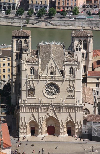 AttractionPrimatiale Saint-Jean de Lyon300 m west, in Lyon 5e2
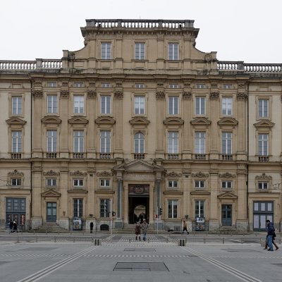 MuseumMusée des Beaux-Arts de Lyon800 m north, in Lyon 1er3
 AttractionParc Olympique lyonnais12 km east, in Décines-Charpieu4AttractionAttractionThéâtre antique de Lyon800 m west, in Lyon 5e5GardenGardenParc de la Tête d'Or2.9 km northeast, in Lyon 6e6AttractionAttractionOdéon antique de Lyon900 m west, in Lyon 5e7
 MuseumGadagne500 m northwest, in Lyon 5e8
 MuseumLugdunum800 m west, in Lyon 5e
Within 15 km, close and well known first. Numbers match the map.
Your questions on Omart
Where is Omart?
Omart is in Lyon 2e, in Rhône (Auvergne-Rhône-Alpes).
What is Omart?
Art gallery.
When is the best time to visit Omart?
April to October are the warmest months in Lyon 2e, with afternoon highs of 17–28°C (Météo-France 1991–2020 normals).
What else is there to see near Omart?
Within 15 km: Primatiale Saint-Jean de Lyon (300 m), Musée des Beaux-Arts de Lyon (800 m), Parc Olympique lyonnais (12 km) and Théâtre antique de Lyon (800 m).
Sources: OpenStreetMap (© OpenStreetMap contributors, ODbL), Wikidata (CC0: what it is, its articles, how widely it is covered), the Culture ministry’s Mérimée database (Licence Ouverte 2.0), IGN commune boundaries, Météo-France 1991–2020 normals (Licence Ouverte 2.0).
Photos from Wikimedia Commons, each under its own licence (our copy, resized).
Photo credits (5)
- Primatiale Saint-Jean de Lyon: Otourly, CC BY-SA 3.0, Wikimedia Commons
- Musée des Beaux-Arts de Lyon: Jastrow, CC BY 2.5, Wikimedia Commons
- Parc Olympique lyonnais: AsGunReview, CC BY-SA 4.0, Wikimedia Commons
- Gadagne: Mathilde HOSPITAL (Gadagne), CC BY-SA 4.0, Wikimedia Commons
- Lugdunum: Alorange, Public domain, Wikimedia Commons
Contains public sector information under the Licence Ouverte / Open Licence 2.0 (Etalab): INSEE, DGFiP, the Interior Ministry’s statistics service (SSMSI), the Ministry of Education (DEPP), the Health Ministry’s statistics service (DREES) and the Housing Ministry (Carte des loyers). Commune boundaries: IGN Admin Express.