
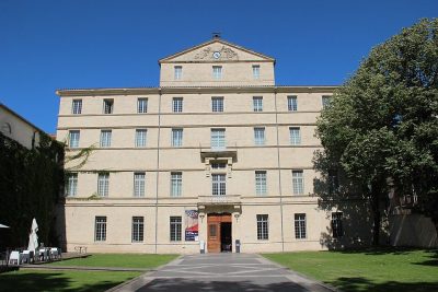
Musée archéologique Henri-Prades
Visitors to Lattes can see Musée archéologique Henri-Prades, a museum. Our list has 15 more places within 5 km. A short trip away is Musée Fabre, 5.6 km off.
Museum in Lattes
In Lattes
Musée archéologique Henri-Prades is in the commune of Lattes, with 15 more places to visit within 5 km. Towns near it ↓
Written from OpenStreetMap, Wikidata and Météo-France 1991–2020 normals.
How the seasons run
The warmest stretch in Lattes is April to October, at 19–30°C in the afternoon.
Musée archéologique Henri-Prades
Its Wikipedia coverage spans 2 languages.
- Type
- Museum
- Covered in
- 2 Wikipedia and sister-site articles
- Commune
- Lattes, Hérault
- Official site
- museearcheo.montpellier3m.fr
Hours, entry and address
- EntryA fee is charged
Getting to Musée archéologique Henri-Prades
The map centres on Musée archéologique Henri-Prades, in orange, with nearby places numbered.
© OpenStreetMap contributors · The dashed line is the commune of Lattes. · commune boundary: IGN
Which town is nearest
Montpellier is the biggest of the 8 bases nearby (310,240 people). From nearest to farthest, these towns all list it.
- 1Lattes
- 2Pérols
- 3Palavas-les-Flots
- 4Villeneuve-lès-Maguelone
- 5Montpellier
- 6Saint-Jean-de-Védas
- 7Castelnau-le-Lez
- 8Mauguio
Lattes
Pérols
Palavas-les-Flots
Villeneuve-lès-Maguelone
Compare the 8 towns
| Town | Where Musée archéologique Henri-Prades is | People |
|---|---|---|
| Lattes | It’s in this commune | 17,351 |
| Pérols | 3.5 km east of it | 9,615 |
| Palavas-les-Flots | 4.5 km southeast of it | 6,133 |
| Villeneuve-lès-Maguelone | 5.5 km southwest of it | 10,872 |
| Montpellier | 6.2 km northwest of it | 310,240 |
| Saint-Jean-de-Védas | 6.5 km west of it | 13,328 |
| Castelnau-le-Lez | 7.9 km north of it | 26,058 |
| Mauguio | 8.3 km northeast of it | 16,522 |
Around Musée archéologique Henri-Prades
There are 129 within 15 km, 2 châteaux, a gallery and a museum among them.
 Art galleryMusée Fabre5.6 km northwest, in Montpellier2
 MuseumLattara100 m west, in Lattes3CathedralCathedralCathédrale Saint-Pierre de Montpellier6 km northwest, in Montpellier4FortFortArc de triomphe de Montpellier5.8 km northwest, in Montpellier5
 GardenJardin des plantes de Montpellier6.1 km northwest, in Montpellier6
 ChâteauChâteau de Flaugergues5 km north, in Montpellier7AttractionAttractionPhare de la Méditerranée4.6 km southeast, in Palavas-les-Flots8
 ChâteauCitadelle de Montpellier5.4 km north, in Montpellier
Within 15 km, close and well known first. Numbers match the map.
A visit to Musée archéologique Henri-Prades: questions
Where is Musée archéologique Henri-Prades?
Musée archéologique Henri-Prades is in Lattes, in Hérault (Occitanie).
What is Musée archéologique Henri-Prades?
Museum in France.
How well known is Musée archéologique Henri-Prades?
Musée archéologique Henri-Prades has 2 Wikipedia and sister-site articles in different languages: #5,252 of the 37,318 French places we list.
When is the best time to visit Musée archéologique Henri-Prades?
April to October are the warmest months in Lattes, with afternoon highs of 19–30°C (Météo-France 1991–2020 normals).
What else is there to see near Musée archéologique Henri-Prades?
Within 15 km: Musée Fabre (5.6 km), Lattara (100 m), Cathédrale Saint-Pierre de Montpellier (6 km) and Arc de triomphe de Montpellier (5.8 km).
Sources: OpenStreetMap (© OpenStreetMap contributors, ODbL), Wikidata (CC0: what it is, its articles, how widely it is covered), the Culture ministry’s Mérimée database (Licence Ouverte 2.0), IGN commune boundaries, Météo-France 1991–2020 normals (Licence Ouverte 2.0).
Photos from Wikimedia Commons, each under its own licence (our copy, resized).
Photo credits (6)
- Musée archéologique Henri-Prades: Arnaud Fafournoux, CC BY-SA 3.0, Wikimedia Commons
- Musée Fabre: Björn S., CC BY-SA 3.0, Wikimedia Commons
- Lattara: Arnaud Fafournoux, CC BY-SA 3.0, Wikimedia Commons
- Jardin des plantes de Montpellier: Alexander Baranov from Montpellier, France, CC BY 2.0, Wikimedia Commons
- Château de Flaugergues: Vpe, CC BY-SA 3.0, Wikimedia Commons
- Citadelle de Montpellier: Photographié et édité par User:Sebjarod (floutage des plaques d'immatriculation), décembre 2004., Public domain, Wikimedia Commons
Contains public sector information under the Licence Ouverte / Open Licence 2.0 (Etalab): INSEE, DGFiP, the Interior Ministry’s statistics service (SSMSI), the Ministry of Education (DEPP), the Health Ministry’s statistics service (DREES) and the Housing Ministry (Carte des loyers). Commune boundaries: IGN Admin Express.