Manoir de Laleu
Look for Manoir de Laleu, a château, in Valloire-sur-Cisse. Close by, within 5 km, are 7 more places to see. It was listed in 1937 as a registered historic monument (inscrit).
Château in Valloire-sur-Cisse
In Valloire-sur-Cisse
Manoir de Laleu is in the commune of Valloire-sur-Cisse, with 7 more places to visit within 5 km. Towns near it ↓
Registered historic monument (inscrit)
Protected as a historic monument since 1937 (Mérimée record PA00098420). About ↓
Written from OpenStreetMap, Wikidata, the Culture ministry’s Mérimée database and Météo-France 1991–2020 normals.
The seasons here
May to October are the warmest in Valloire-sur-Cisse, with afternoon highs of 17–26°C.
Manoir de Laleu
2 Wikipedia editions have an article on it. Worth the trip, Château de Chaumont-sur-Loire is 3.9 km off.
- Type
- Château
- Protection
- Registered historic monument (inscrit) · 1937
- Covered in
- 2 Wikipedia and sister-site articles
- Commune
- Valloire-sur-Cisse, Loir-et-Cher
Where to find Manoir de Laleu
The map centres on Manoir de Laleu, in orange, with nearby places numbered.
© OpenStreetMap contributors · The dashed line is the commune of Valloire-sur-Cisse. · commune boundary: IGN
Towns around Manoir de Laleu, by distance
Among the 8, Blois is the biggest, home to 47,219 people. Every town below has its own grades, prices and places to visit.
- 1Valloire-sur-Cisse
- 2Veuzain-sur-Loire
- 3Chailles
- 4Blois
- 5Saint-Gervais-la-Forêt
- 6Cellettes
- 7Villebarou
- 8Vineuil
Valloire-sur-Cisse
Veuzain-sur-Loire
Chailles
Blois
Compare the 8 towns
| Town | Where Manoir de Laleu is | People |
|---|---|---|
| Valloire-sur-Cisse | It’s in this commune | 2,385 |
| Veuzain-sur-Loire | 2.8 km southwest of it | 3,333 |
| Chailles | 8.2 km east of it | 2,726 |
| Blois | 12 km northeast of it | 47,219 |
| Saint-Gervais-la-Forêt | 13 km northeast of it | 3,180 |
| Cellettes | 14 km east of it | 2,715 |
| Villebarou | 16 km northeast of it | 2,584 |
| Vineuil | 16 km northeast of it | 8,064 |
Also within reach
69 more lie within 15 km, 5 attractions, a cathedral and a museum among them.
 AttractionChâteau de Blois13 km northeast, in Blois3CathedralCathedralCathédrale Saint-Louis de Blois13 km northeast, in Blois4
 AttractionChâteau de Beauregard14 km east, in Cellettes5
 AttractionChâteau de Fougères-sur-Bièvre13 km southeast, in Le Controis-en-Sologne6
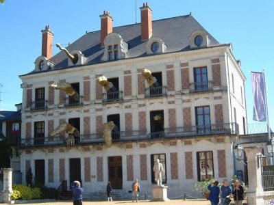 MuseumMaison de la Magie13 km northeast, in Blois7Monastery or conventMonastery or conventAbbaye de la Guiche3.7 km northeast, in Valloire-sur-Cisse8AttractionAttractionHôtel d'Alluye13 km northeast, in Blois
Within 15 km, close and well known first. Numbers match the map.
Visiting Manoir de Laleu: the answers
Where is Manoir de Laleu?
Manoir de Laleu is in Valloire-sur-Cisse, in Loir-et-Cher (Centre-Val de Loire).
What is Manoir de Laleu?
Château.
Is Manoir de Laleu a historic monument?
Yes: Registered historic monument (inscrit), since 1937, Mérimée record PA00098420.
How well known is Manoir de Laleu?
Manoir de Laleu has 2 Wikipedia and sister-site articles in different languages: #5,252 of the 37,318 French places we list.
When is the best time to visit Manoir de Laleu?
May to October are the warmest months in Valloire-sur-Cisse, with afternoon highs of 17–26°C (Météo-France 1991–2020 normals).
What else is there to see near Manoir de Laleu?
Within 15 km: Château de Chaumont-sur-Loire (3.9 km), Château de Blois (13 km), Cathédrale Saint-Louis de Blois (13 km) and Château de Beauregard (14 km).
Sources: OpenStreetMap (© OpenStreetMap contributors, ODbL), Wikidata (CC0: what it is, its articles, how widely it is covered), the Culture ministry’s Mérimée database (Licence Ouverte 2.0), IGN commune boundaries, Météo-France 1991–2020 normals (Licence Ouverte 2.0).
Photos from Wikimedia Commons, each under its own licence (our copy, resized).
Photo credits (4)
- Château de Blois: Tango7174, CC BY-SA 4.0, Wikimedia Commons
- Château de Beauregard: Gerd Eichmann, CC BY-SA 4.0, Wikimedia Commons
- Château de Fougères-sur-Bièvre: Patrick Clenet, CC BY-SA 3.0, Wikimedia Commons
- Maison de la Magie: You may select the license of your choice., CC BY-SA 3.0, Wikimedia Commons
Contains public sector information under the Licence Ouverte / Open Licence 2.0 (Etalab): INSEE, DGFiP, the Interior Ministry’s statistics service (SSMSI), the Ministry of Education (DEPP), the Health Ministry’s statistics service (DREES) and the Housing Ministry (Carte des loyers). Commune boundaries: IGN Admin Express.