La Flégère
Visitors to Chamonix-Mont-Blanc can see La Flégère, an attraction. Our list has 22 more places within 5 km. Top of the list nearby is Aiguille du Midi, 9.1 km away.
Attraction in Chamonix-Mont-Blanc
One of the best-known places to visit in France
#3,165 of the 37,318 museums, châteaux, gardens and other attractions we list in France, by how widely it is covered (3 Wikipedia and sister-site articles). About ↓
In Chamonix-Mont-Blanc
La Flégère is in the commune of Chamonix-Mont-Blanc, with 22 more places to visit within 5 km. Towns near it ↓
Written from OpenStreetMap, Wikidata and Météo-France 1991–2020 normals.
When to go
In Chamonix-Mont-Blanc the warm season is May to September, with highs of 18–24°C.
La Flégère
3 Wikipedia editions have an article on it.
- Type
- Attraction
- Covered in
- 3 Wikipedia and sister-site articles
- Commune
- Chamonix-Mont-Blanc, Haute-Savoie
La Flégère on the map
La Flégère is in orange, with the places near it numbered as below.
© OpenStreetMap contributors · The dashed line is the commune of Chamonix-Mont-Blanc. · commune boundary: IGN
Which towns are near La Flégère
Of these 7 towns, the largest is Sallanches (17,319 people). The list runs from its own town outward.
Chamonix-Mont-Blanc
Les Houches
Passy
Saint-Gervais-les-Bains
Compare the 7 towns
| Town | Where La Flégère is | People |
|---|---|---|
| Chamonix-Mont-Blanc | It’s in this commune | 8,705 |
| Les Houches | 9.7 km southwest of it | 3,515 |
| Passy | 15 km west of it | 10,856 |
| Saint-Gervais-les-Bains | 16 km southwest of it | 5,755 |
| Sallanches | 20 km west of it | 17,319 |
| Magland | 21 km west of it | 3,220 |
| Megève | 24 km southwest of it | 2,893 |
Also near La Flégère
There are 41 within 15 km, 6 attractions and 2 museums among them.
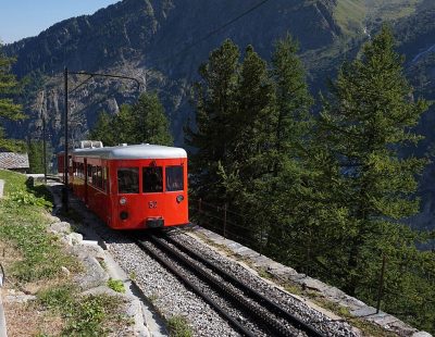 MuseumChemin de fer du Montenvers4.3 km south, in Chamonix-Mont-Blanc4
 AttractionCompagnie des guides de Chamonix5.9 km southwest, in Chamonix-Mont-Blanc5AttractionAttractionMontenvers4 km southeast, in Chamonix-Mont-Blanc6
 AttractionGrotte de glace de la Mer de Glace4.7 km southeast, in Chamonix-Mont-Blanc7AttractionAttractionPlanpraz3.7 km southwest, in Chamonix-Mont-Blanc8
 MuseumTemple de la Nature4 km southeast, in Chamonix-Mont-Blanc
Within 15 km, close and well known first. Numbers match the map.
La Flégère: what to know
Where is La Flégère?
La Flégère is in Chamonix-Mont-Blanc, in Haute-Savoie (Auvergne-Rhône-Alpes).
What is La Flégère?
Mountain in France.
How well known is La Flégère?
La Flégère has 3 Wikipedia and sister-site articles in different languages: #3,165 of the 37,318 French places we list.
When is the best time to visit La Flégère?
May to September are the warmest months in Chamonix-Mont-Blanc, with afternoon highs of 18–24°C (Météo-France 1991–2020 normals).
What else is there to see near La Flégère?
Within 15 km: Aiguille du Midi (9.1 km), Le Brévent (4.8 km), Chemin de fer du Montenvers (4.3 km) and Compagnie des guides de Chamonix (5.9 km).
Sources: OpenStreetMap (© OpenStreetMap contributors, ODbL), Wikidata (CC0: what it is, its articles, how widely it is covered), the Culture ministry’s Mérimée database (Licence Ouverte 2.0), IGN commune boundaries, Météo-France 1991–2020 normals (Licence Ouverte 2.0).
Photos from Wikimedia Commons, each under its own licence (our copy, resized).
Photo credits (4)
- Chemin de fer du Montenvers: Tiia Monto, CC BY-SA 3.0, Wikimedia Commons
- Compagnie des guides de Chamonix: Calips, CC BY-SA 3.0, Wikimedia Commons
- Grotte de glace de la Mer de Glace: Tiia Monto, CC BY-SA 3.0, Wikimedia Commons
- Temple de la Nature: Rémih, CC BY-SA 4.0, Wikimedia Commons
Contains public sector information under the Licence Ouverte / Open Licence 2.0 (Etalab): INSEE, DGFiP, the Interior Ministry’s statistics service (SSMSI), the Ministry of Education (DEPP), the Health Ministry’s statistics service (DREES) and the Housing Ministry (Carte des loyers). Commune boundaries: IGN Admin Express.