
Jardin du Luxembourg
Jardin du Luxembourg is an urban park. It lies in Paris 6e itself. There are 2,191 more places to see within 15 km, beginning with Musée du Louvre (1.6 km).
Attraction in Paris 6e
One of the best-known places to visit in France
#48 of the 37,318 museums, châteaux, gardens and other attractions we list in France, by how widely it is covered (51 Wikipedia and sister-site articles). About ↓
In Paris 6e
Jardin du Luxembourg is in the commune of Paris 6e, with 1,479 more places to visit within 5 km. Towns near it ↓
Written from OpenStreetMap, Wikidata and Météo-France 1991–2020 normals.
When to go
In Paris 6e the warm season is April to October, with highs of 18–27°C.
Jardin du Luxembourg
Articles on it exist in 51 languages.
- Type
- Attraction
- Covered in
- 51 Wikipedia and sister-site articles
- Commune
- Paris 6e, Paris
- Official site
- jardin.senat.fr
When it is open
Where to find Jardin du Luxembourg
Orange marks Jardin du Luxembourg, and the numbered points match the list of places below.
© OpenStreetMap contributors · The dashed line is the commune of Paris 6e. · commune boundary: IGN
Bases near Jardin du Luxembourg
Paris 14e tops the 8 for size, at 136,455 people. The towns are in order of distance, its own town first.
Paris 6e
Paris 5e
Paris 1er
Paris 4e
Compare the 8 towns
| Town | Where Jardin du Luxembourg is | People |
|---|---|---|
| Paris 6e | It’s in this commune | 40,389 |
| Paris 5e | 1.1 km east of it | 55,252 |
| Paris 1er | 1.8 km north of it | 15,114 |
| Paris 4e | 2 km northeast of it | 27,332 |
| Paris 7e | 2 km northwest of it | 48,015 |
| Paris 14e | 2.1 km southwest of it | 136,455 |
| Paris 2e | 2.4 km north of it | 19,847 |
| Paris 3e | 2.5 km northeast of it | 32,179 |
After Jardin du Luxembourg
Nearby, 2,191 places within 15 km include 5 attractions, 2 museums and a château.
 AttractionTour Eiffel3.3 km northwest, in Paris 7e3
 AttractionCathédrale Notre-Dame de Paris1.2 km northeast, in Paris 4e4
 MuseumMusée d'Orsay1.6 km northwest, in Paris 7e5AttractionAttractionPendule de Foucault700 m east, in Paris 5e6
 AttractionPanthéon700 m east, in Paris 5e7
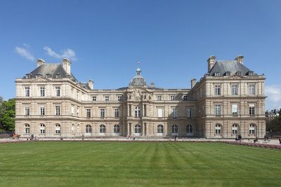 ChâteauPalais du Luxembourg200 m northeast, in Paris 6e8
 AttractionAvenue des Champs-Élysées3.5 km northwest, in Paris 8e
Within 15 km, close and well known first. Numbers match the map.
Quick answers on Jardin du Luxembourg
Where is Jardin du Luxembourg?
Jardin du Luxembourg is in Paris 6e, in Paris (Île-de-France).
What is Jardin du Luxembourg?
Urban park in Paris, France.
How well known is Jardin du Luxembourg?
Jardin du Luxembourg has 51 Wikipedia and sister-site articles in different languages: #48 of the 37,318 French places we list.
When is the best time to visit Jardin du Luxembourg?
April to October are the warmest months in Paris 6e, with afternoon highs of 18–27°C (Météo-France 1991–2020 normals).
What else is there to see near Jardin du Luxembourg?
Within 15 km: Musée du Louvre (1.6 km), Tour Eiffel (3.3 km), Cathédrale Notre-Dame de Paris (1.2 km) and Musée d'Orsay (1.6 km).
Sources: OpenStreetMap (© OpenStreetMap contributors, ODbL), Wikidata (CC0: what it is, its articles, how widely it is covered), the Culture ministry’s Mérimée database (Licence Ouverte 2.0), IGN commune boundaries, Météo-France 1991–2020 normals (Licence Ouverte 2.0).
Photos from Wikimedia Commons, each under its own licence (our copy, resized).
Photo credits (7)
- Jardin du Luxembourg: Kirua, Public domain, Wikimedia Commons
- Tour Eiffel: Benh LIEU SONG, Public domain, Wikimedia Commons
- Cathédrale Notre-Dame de Paris: P e z i, CC BY-SA 3.0, Wikimedia Commons
- Musée d'Orsay: Cheng-en Cheng from Taichung City, Taiwan, CC BY-SA 2.0, Wikimedia Commons
- Panthéon: Camille Gévaudan, CC BY-SA 3.0, Wikimedia Commons
- Palais du Luxembourg: Luis Miguel Bugallo Sánchez (Lmbuga), CC BY-SA 4.0, Wikimedia Commons
- Avenue des Champs-Élysées: SoWhat, CC BY-SA 2.0, Wikimedia Commons
Contains public sector information under the Licence Ouverte / Open Licence 2.0 (Etalab): INSEE, DGFiP, the Interior Ministry’s statistics service (SSMSI), the Ministry of Education (DEPP), the Health Ministry’s statistics service (DREES) and the Housing Ministry (Carte des loyers). Commune boundaries: IGN Admin Express.