Glacière
This is Glacière, an attraction in Bourron-Marlotte. Our list has 6 more places within 5 km. A drive of 6.9 km reaches Château de Fontainebleau.
Attraction in Bourron-Marlotte
In Bourron-Marlotte
Glacière is in the commune of Bourron-Marlotte, with 6 more places to visit within 5 km. Towns near it ↓
Written from OpenStreetMap, Wikidata and Météo-France 1991–2020 normals.
The year in Bourron-Marlotte
Warm weather in Bourron-Marlotte runs May to October, with highs of 17–27°C.
Glacière
Attraction.
Glacière is in Bourron-Marlotte, Seine-et-Marne.
- Type
- Attraction
- Commune
- Bourron-Marlotte, Seine-et-Marne
Where to find Glacière
Orange marks Glacière, and the numbered points match the list of places below.
© OpenStreetMap contributors · The dashed line is the commune of Bourron-Marlotte. · commune boundary: IGN
Where to base yourself
With 15,583 people, Fontainebleau is the largest of the 8. From nearest to farthest, these towns all list it.
- 1Bourron-Marlotte
- 2Montigny-sur-Loing
- 3Fontainebleau
- 4Saint-Pierre-lès-Nemours
- 5Nemours
- 6Avon
- 7Moret-Loing-et-Orvanne
- 8Thomery
Bourron-Marlotte
Montigny-sur-Loing
Fontainebleau
Saint-Pierre-lès-Nemours
Compare the 8 towns
| Town | Where Glacière is | People |
|---|---|---|
| Bourron-Marlotte | It’s in this commune | 2,774 |
| Montigny-sur-Loing | 3.7 km east of it | 2,669 |
| Fontainebleau | 7.6 km north of it | 15,583 |
| Saint-Pierre-lès-Nemours | 8.1 km south of it | 5,401 |
| Nemours | 8.1 km south of it | 12,889 |
| Avon | 8.4 km north of it | 13,651 |
| Moret-Loing-et-Orvanne | 9.2 km east of it | 12,810 |
| Thomery | 9.9 km northeast of it | 3,384 |
While you are near Glacière
Among the 87 within 15 km are 4 museums, 3 châteaux and a fort.
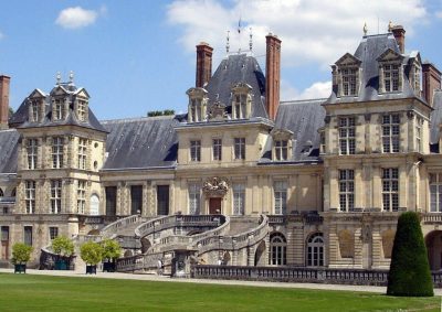 ChâteauChâteau de Fontainebleau6.9 km north, in Fontainebleau2
 ChâteauChâteau de Bourron300 m east, in Bourron-Marlotte3
 MuseumChâteau de Nemours8.3 km south, in Nemours4
 MuseumMusée de l'atelier Rosa Bonheur9.1 km northeast, in Thomery5MuseumMuseumTacot des Lacs3.2 km south, in Grez-sur-Loing6
 ChâteauChâteau de Moret9.9 km east, in Moret-Loing-et-Orvanne7
 MuseumMusée départemental de Préhistoire d'Île-de-France9.1 km south, in Nemours8FortFortTour de Ganne2.7 km south, in Grez-sur-Loing
Within 15 km, close and well known first. Numbers match the map.
Visiting Glacière
Where is Glacière?
Glacière is in Bourron-Marlotte, in Seine-et-Marne (Île-de-France).
What is Glacière?
Attraction.
When is the best time to visit Glacière?
May to October are the warmest months in Bourron-Marlotte, with afternoon highs of 17–27°C (Météo-France 1991–2020 normals).
What else is there to see near Glacière?
Within 15 km: Château de Fontainebleau (6.9 km), Château de Bourron (300 m), Château de Nemours (8.3 km) and Musée de l'atelier Rosa Bonheur (9.1 km).
Sources: OpenStreetMap (© OpenStreetMap contributors, ODbL), Wikidata (CC0: what it is, its articles, how widely it is covered), the Culture ministry’s Mérimée database (Licence Ouverte 2.0), IGN commune boundaries, Météo-France 1991–2020 normals (Licence Ouverte 2.0).
Photos from Wikimedia Commons, each under its own licence (our copy, resized).
Photo credits (6)
- Château de Fontainebleau: user:Carolus, CC BY 2.5, Wikimedia Commons
- Château de Bourron: vincent6464, CC BY 3.0, Wikimedia Commons
- Château de Nemours: Pline, CC BY-SA 3.0, Wikimedia Commons
- Musée de l'atelier Rosa Bonheur: Architect : unknown Photography : Teofilo, CC BY-SA 2.0, Wikimedia Commons
- Château de Moret: Reinhardhauke, CC BY-SA 3.0, Wikimedia Commons
- Musée départemental de Préhistoire d'Île-de-France: Serendipita77, CC BY-SA 3.0, Wikimedia Commons
Contains public sector information under the Licence Ouverte / Open Licence 2.0 (Etalab): INSEE, DGFiP, the Interior Ministry’s statistics service (SSMSI), the Ministry of Education (DEPP), the Health Ministry’s statistics service (DREES) and the Housing Ministry (Carte des loyers). Commune boundaries: IGN Admin Express.