Fort Faron
Toulon counts Fort Faron among its places to visit. Add any of 37 more places within 5 km to a visit. Since 2021 it has been a registered historic monument (inscrit).
Fort in Toulon
In Toulon
Fort Faron is in the commune of Toulon, with 37 more places to visit within 5 km. Towns near it ↓
Registered historic monument (inscrit)
Protected as a historic monument since 2021; built in the 19th century (Mérimée record PA83000051). About ↓
Written from OpenStreetMap, Wikidata, the Culture ministry’s Mérimée database and Météo-France 1991–2020 normals.
Seasons in Toulon
Warm weather in Toulon runs April to October, with highs of 19–30°C.
Fort Faron
First among the places near it is Cathédrale Notre-Dame-de-la-Seds de Toulon, at 2.8 km.
- Type
- Fort
- Protection
- Registered historic monument (inscrit) · 2021
- Built
- 19th century
- Commune
- Toulon, Var
Fort Faron at a glance
Fort Faron sits at the orange dot; the numbered ones are listed below.
© OpenStreetMap contributors · The dashed line is the commune of Toulon. · commune boundary: IGN
Where people come from
The biggest base of the 8 is Toulon (179,116 people). Start with its own town; the others follow by distance.
- 1Toulon
- 2La Valette-du-Var
- 3Le Revest-les-Eaux
- 4La Garde
- 5Le Pradet
- 6La Farlède
- 7Saint-Mandrier-sur-Mer
- 8Solliès-Ville
Toulon
La Valette-du-Var
Le Revest-les-Eaux
La Garde
Compare the 8 towns
| Town | Where Fort Faron is | People |
|---|---|---|
| Toulon | It’s in this commune | 179,116 |
| La Valette-du-Var | 2.7 km east of it | 23,719 |
| Le Revest-les-Eaux | 4.3 km northwest of it | 4,074 |
| La Garde | 4.4 km southeast of it | 26,476 |
| Le Pradet | 6.5 km southeast of it | 10,933 |
| La Farlède | 7.5 km east of it | 10,014 |
| Saint-Mandrier-sur-Mer | 7.7 km southwest of it | 6,000 |
| Solliès-Ville | 8 km northeast of it | 2,504 |
Other places close by
Of the 95 within 15 km, look for 3 attractions, 2 museums and a cathedral.
 CathedralCathédrale Notre-Dame-de-la-Seds de Toulon2.8 km southwest, in Toulon2AttractionAttractionFNRS-34.8 km southwest, in Toulon3
 MuseumMusée national de la Marine de Toulon3.1 km southwest, in Toulon4
 MuseumMusée d'Art de Toulon2.9 km southwest, in Toulon5FortFortTour royale4.9 km southwest, in Toulon6
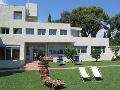 AttractionVilla Noailles14 km east, in Hyères7
 AttractionZénith Oméga de Toulon2.5 km southwest, in Toulon8ZooZooZoo du Mont Faron2.1 km northwest, in Toulon
Within 15 km, close and well known first. Numbers match the map.
Questions before you go
Where is Fort Faron?
Fort Faron is in Toulon, in Var (Provence-Alpes-Côte d'Azur).
What is Fort Faron?
Fort.
Is Fort Faron a historic monument?
Yes: Registered historic monument (inscrit), since 2021, Mérimée record PA83000051.
When is the best time to visit Fort Faron?
April to October are the warmest months in Toulon, with afternoon highs of 19–30°C (Météo-France 1991–2020 normals).
What else is there to see near Fort Faron?
Within 15 km: Cathédrale Notre-Dame-de-la-Seds de Toulon (2.8 km), FNRS-3 (4.8 km), Musée national de la Marine de Toulon (3.1 km) and Musée d'Art de Toulon (2.9 km).
Sources: OpenStreetMap (© OpenStreetMap contributors, ODbL), Wikidata (CC0: what it is, its articles, how widely it is covered), the Culture ministry’s Mérimée database (Licence Ouverte 2.0), IGN commune boundaries, Météo-France 1991–2020 normals (Licence Ouverte 2.0).
Photos from Wikimedia Commons, each under its own licence (our copy, resized).
Photo credits (5)
- Cathédrale Notre-Dame-de-la-Seds de Toulon: Raimond Spekking, CC BY-SA 4.0, Wikimedia Commons
- Musée national de la Marine de Toulon: SiefkinDR, Public domain, Wikimedia Commons
- Musée d'Art de Toulon: Rvalette, CC BY-SA 3.0, Wikimedia Commons
- Villa Noailles: Daniel Wilk, CC BY-SA 3.0, Wikimedia Commons
- Zénith Oméga de Toulon: Lembeye, CC BY-SA 3.0, Wikimedia Commons
Contains public sector information under the Licence Ouverte / Open Licence 2.0 (Etalab): INSEE, DGFiP, the Interior Ministry’s statistics service (SSMSI), the Ministry of Education (DEPP), the Health Ministry’s statistics service (DREES) and the Housing Ministry (Carte des loyers). Commune boundaries: IGN Admin Express.