Château de Balsac
Druelle Balsac counts Château de Balsac among its places to visit. Nearby, 2 more places to visit are within 5 km. Since 2007 it has been a registered historic monument (inscrit, in part).
Château in Druelle Balsac
In Druelle Balsac
Château de Balsac is in the commune of Druelle Balsac, with 2 more places to visit within 5 km. Towns near it ↓
Registered historic monument (inscrit, in part)
Protected as a historic monument since 2007; built in the 16th century (Mérimée record PA12000040). About ↓
Written from OpenStreetMap, Wikidata, the Culture ministry’s Mérimée database and Météo-France 1991–2020 normals.
The climate through the year
In Druelle Balsac, May to September bring the warmest days: highs of 19–26°C.
Château de Balsac
There are Wikipedia articles on it in 2 languages. Add Cathédrale Notre-Dame de Rodez, 12 km away, to a visit.
- Type
- Château
- Protection
- Registered historic monument (inscrit, in part) · 2007
- Built
- 16th century
- Covered in
- 2 Wikipedia and sister-site articles
- Commune
- Druelle Balsac, Aveyron
The way to Château de Balsac
The map centres on Château de Balsac, in orange, with nearby places numbered.
© OpenStreetMap contributors · The dashed line is the commune of Druelle Balsac. · commune boundary: IGN
Towns close to Château de Balsac
Rodez is the biggest of the 8 bases nearby (23,981 people). All of these towns include it on their pages.
Druelle Balsac
Onet-le-Château
Olemps
Rodez
Compare the 8 towns
| Town | Where Château de Balsac is | People |
|---|---|---|
| Druelle Balsac | It’s in this commune | 3,187 |
| Onet-le-Château | 11 km east of it | 12,080 |
| Olemps | 11 km southeast of it | 3,559 |
| Rodez | 12 km southeast of it | 23,981 |
| Sébazac-Concourès | 13 km east of it | 3,234 |
| Baraqueville | 14 km south of it | 3,173 |
| Luc-la-Primaube | 14 km southeast of it | 6,046 |
| Aubin | 21 km northwest of it | 3,444 |
Also near Château de Balsac
The 52 places within 15 km include 3 châteaux, 3 museums and an attraction.
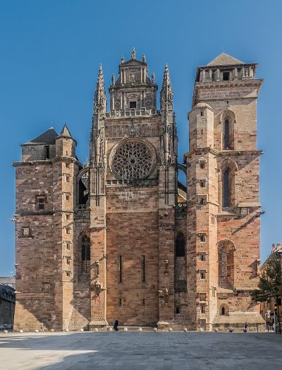 AttractionCathédrale Notre-Dame de Rodez12 km southeast, in Rodez2ChâteauChâteauChâteau de Belcastel8.7 km west, in Belcastel3AbbeyAbbeyPrieuré du Sauvage2.1 km southeast, in Druelle Balsac4
 MuseumMusée des beaux-arts Denys-Puech12 km southeast, in Rodez5ChâteauChâteauChâteau de Panat3.5 km northwest, in Clairvaux-d'Aveyron6
 MuseumMusée Soulages11 km southeast, in Rodez7
 MuseumMusée Fenaille12 km southeast, in Rodez8ChâteauChâteauChâteau de Bournazel13 km northwest, in Bournazel
Within 15 km, close and well known first. Numbers match the map.
Château de Balsac: what to know
Where is Château de Balsac?
Château de Balsac is in Druelle Balsac, in Aveyron (Occitanie).
What is Château de Balsac?
Château.
Is Château de Balsac a historic monument?
Yes: Registered historic monument (inscrit, in part), since 2007, Mérimée record PA12000040.
How well known is Château de Balsac?
Château de Balsac has 2 Wikipedia and sister-site articles in different languages: #5,252 of the 37,318 French places we list.
When is the best time to visit Château de Balsac?
May to September are the warmest months in Druelle Balsac, with afternoon highs of 19–26°C (Météo-France 1991–2020 normals).
What else is there to see near Château de Balsac?
Within 15 km: Cathédrale Notre-Dame de Rodez (12 km), Château de Belcastel (8.7 km), Prieuré du Sauvage (2.1 km) and Musée des beaux-arts Denys-Puech (12 km).
Sources: OpenStreetMap (© OpenStreetMap contributors, ODbL), Wikidata (CC0: what it is, its articles, how widely it is covered), the Culture ministry’s Mérimée database (Licence Ouverte 2.0), IGN commune boundaries, Météo-France 1991–2020 normals (Licence Ouverte 2.0).
Photos from Wikimedia Commons, each under its own licence (our copy, resized).
Photo credits (4)
- Cathédrale Notre-Dame de Rodez: Krzysztof Golik, CC BY-SA 4.0, Wikimedia Commons
- Musée des beaux-arts Denys-Puech: Krzysztof Golik, CC BY-SA 4.0, Wikimedia Commons
- Musée Soulages: Calips, CC BY-SA 3.0, Wikimedia Commons
- Musée Fenaille: Krzysztof Golik, CC BY-SA 4.0, Wikimedia Commons
Contains public sector information under the Licence Ouverte / Open Licence 2.0 (Etalab): INSEE, DGFiP, the Interior Ministry’s statistics service (SSMSI), the Ministry of Education (DEPP), the Health Ministry’s statistics service (DREES) and the Housing Ministry (Carte des loyers). Commune boundaries: IGN Admin Express.