Chapelle Saint-Blaise d'Hyères
Chapelle Saint-Blaise d'Hyères is a chapel located. Hyères is where it stands. Since 1987 it has been a classé historic monument.
Château in Hyères
In Hyères
Chapelle Saint-Blaise d'Hyères is in the commune of Hyères, with 17 more places to visit within 5 km. Towns near it ↓
Classé historic monument
Protected as a historic monument since 1987; built in the 13th century (Mérimée record PA00081636). About ↓
Written from OpenStreetMap, Wikidata, the Culture ministry’s Mérimée database and Météo-France 1991–2020 normals.
The seasons here
The warmest stretch in Hyères is April to November, at 17–29°C in the afternoon.
Chapelle Saint-Blaise d'Hyères
There are Wikipedia articles on it in 2 languages. Look also at Villa Noailles, 300 m away, first of 65 more within 15 km.
- Type
- Château
- Protection
- Classé historic monument · 1987
- Built
- 13th century
- Covered in
- 2 Wikipedia and sister-site articles
- Commune
- Hyères, Var
Where to find Chapelle Saint-Blaise d'Hyères
On this map, Chapelle Saint-Blaise d'Hyères is orange and its neighbours are numbered.
© OpenStreetMap contributors · The dashed line is the commune of Hyères. · commune boundary: IGN
Which towns are near Chapelle Saint-Blaise d'Hyères
Hyères is the biggest of the 8 bases nearby (55,858 people). Pick a base: each town is a page of its own, with what else there is to see.
Hyères
La Crau
Carqueiranne
La Farlède
Compare the 8 towns
| Town | Where Chapelle Saint-Blaise d'Hyères is | People |
|---|---|---|
| Hyères | It’s in this commune | 55,858 |
| La Crau | 4.8 km northwest of it | 19,556 |
| Carqueiranne | 5.3 km southwest of it | 9,408 |
| La Farlède | 8.4 km northwest of it | 10,014 |
| Le Pradet | 8.8 km west of it | 10,933 |
| La Londe-les-Maures | 9.2 km east of it | 10,584 |
| Solliès-Ville | 9.6 km northwest of it | 2,504 |
| La Garde | 9.9 km west of it | 26,476 |
What else is near Chapelle Saint-Blaise d'Hyères
Nearby, 65 places within 15 km include 4 forts, an attraction and a château.
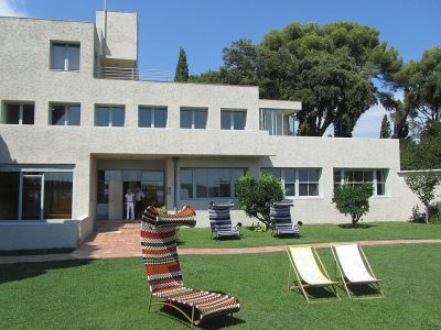 AttractionVilla Noailles300 m north, in Hyères2
 ChâteauChâteau de Hyères400 m northwest, in Hyères3FortFortPorte de Fenouillet200 m southwest, in Hyères4FortFortPorte Saint-Paul100 m west, in Hyères5FortFortPorte de Baruc200 m north, in Hyères6FortFortPorte de la Rade200 m east, in Hyères7AbbeyAbbeyAbbaye Saint-Pierre de l'Almanarre4.5 km south, in Hyères8
 GardenJardin zoologique tropical11 km east, in La Londe-les-Maures
Within 15 km, close and well known first. Numbers match the map.
Chapelle Saint-Blaise d'Hyères, answered
Where is Chapelle Saint-Blaise d'Hyères?
Chapelle Saint-Blaise d'Hyères is in Hyères, in Var (Provence-Alpes-Côte d'Azur).
What is Chapelle Saint-Blaise d'Hyères?
Chapel located in Var, in France.
Is Chapelle Saint-Blaise d'Hyères a historic monument?
Yes: Classé historic monument, since 1987, Mérimée record PA00081636.
How well known is Chapelle Saint-Blaise d'Hyères?
Chapelle Saint-Blaise d'Hyères has 2 Wikipedia and sister-site articles in different languages: #5,252 of the 37,318 French places we list.
When is the best time to visit Chapelle Saint-Blaise d'Hyères?
April to November are the warmest months in Hyères, with afternoon highs of 17–29°C (Météo-France 1991–2020 normals).
What else is there to see near Chapelle Saint-Blaise d'Hyères?
Within 15 km: Villa Noailles (300 m), Château de Hyères (400 m), Porte de Fenouillet (200 m) and Porte Saint-Paul (100 m).
Sources: OpenStreetMap (© OpenStreetMap contributors, ODbL), Wikidata (CC0: what it is, its articles, how widely it is covered), the Culture ministry’s Mérimée database (Licence Ouverte 2.0), IGN commune boundaries, Météo-France 1991–2020 normals (Licence Ouverte 2.0).
Photos from Wikimedia Commons, each under its own licence (our copy, resized).
Photo credits (3)
- Villa Noailles: Daniel Wilk, CC BY-SA 3.0, Wikimedia Commons
- Château de Hyères: Denis Biette, CC BY-SA 2.5, Wikimedia Commons
- Jardin zoologique tropical: Daderot, Public domain, Wikimedia Commons
Contains public sector information under the Licence Ouverte / Open Licence 2.0 (Etalab): INSEE, DGFiP, the Interior Ministry’s statistics service (SSMSI), the Ministry of Education (DEPP), the Health Ministry’s statistics service (DREES) and the Housing Ministry (Carte des loyers). Commune boundaries: IGN Admin Express.