
Tr'ochëk
Also known as Tr’o-ju-wech’in (former name) , Lousetown , Klondike City , Tr’ondëk Hwëch’in Traditional Territory
About Tr'ochëk
Tr'ochëk is one of 8 National Historic Sites in Dawson. Its maker on the record: Tr’ondëk Hwëch’in First Nation. One other place on the registers stands within 400 m.
Tr’ochëk National Historic Site of Canada lies on an upstream flat at the confluence of the Yukon and Klondike Rivers, just south of Dawson City, Yukon. The Klondike River breaches the high hills along the east bank of the Yukon, just skirting the base of a steep hill that rises to form a high, flat bench. The river flat features a large, open grassy meadow that contains the remains of Hän fish camps, traditional plant harvesting areas and bench lookout points that offer views of traditional Tr’ondëk Hëwch’in First Nation land. Official recognition refers to the alluvial flat on the upriver side of the confluence of the Klondike and Yukon rivers, the hillside backing it to the south and a portion of the Yukon River cliffs just upriver of the confluence.
From the Canadian Register of Historic Places, Tr'ochëk National Historic Site of Canada · Open Government Licence – Canada · as published, word for word
A National Historic Site is designated by the federal minister on the Historic Sites and Monuments Board’s advice.
1 old view of Tr'ochëk
Made before 1950, from 1895: public domain or CC0. Tap one to see it full screen.
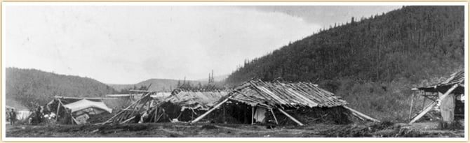 1895
From Wikimedia Commons, copied to our own server; some are drawings, prints or maps of their time. Each credit is in the viewer.
Make it a walk: 2 historic places in about 10 minutes
Dawson · about 400 m on foot, as the crow flies


- 1Tr'ochëkStart here
- 2Dawson Historical ComplexNational Historic Site · 400 m on
Questions about Tr'ochëk
Can you visit Tr'ochëk?
Yes from the outside; whether it opens its doors is for its owner to say.
Is Tr'ochëk protected?
National Historic Site status commemorates; legal protection, where there is any, comes from the province or municipality, or from federal ownership.
What is Tr'ochëk?
Canada named Tr'ochëk a National Historic Site in 2002.
Contains information licensed under the Open Government Licence – Canada (Parks Canada).
Sources: Parks Canada, Directory of Federal Heritage Designations · Canadian Register of Historic Places (federal extract) · Photos: Wikimedia Commons, each credited with its licence and copied to our own server · Wikidata (CC0) for map points, other names and articles.
Adapted from Statistics Canada (Census of Population 2021, population estimates 2025, 2021 census boundaries) under the Statistics Canada Open Licence; this does not constitute an endorsement by Statistics Canada. Neighbourhood names in some cities © OpenStreetMap contributors (ODbL).