
Arvida
In French: Site patrimonial d'Arvida
Arvida, Saguenay
Arvida, 1926 and today
Drag across to compare. The two views aren’t taken from exactly the same spot.

1926: Public domain. Today: Public domain.
About Arvida
In Saguenay, Arvida is one of 4 National Historic Sites. By its record, Arvida was built in 1926–1936. 2 more historic places stand within 400 m of it.
Arvida National Historic Site of Canada is located in the Saguenay-Lac-Saint-Jean region, 250 kilometers north of Quebec City. This company town, built to house employees of the local Alcoa aluminum plant, was designed as a whole, built in three phases and retains many original features. Arvida stretches northwest from the Rio Tinto Alcan plant along the shore of the Saguenay River. Crisscrossed by ravines, the residential town has an institutional zone at its heart and is encircled by a green belt. The town features family dwellings, a hotel, churches, schools, a manoir, green spaces, parks. Official recognition refers to the company town of Arvida that was designed and built in three phases from 1925-1950.
From the Canadian Register of Historic Places, Arvida National Historic Site of Canada · Open Government Licence – Canada · in the register’s words, not edited
National Historic Site status comes on the advice of the Historic Sites and Monuments Board of Canada.
4 old views of Arvida
Made before 1950, from 1926 to 1933: public domain or CC0. Tap one to see it full screen.
1926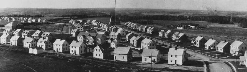 1928
 c. 1930
 1933
From Wikimedia Commons, copied to our own server; some are drawings, prints or maps of their time. Each credit is in the viewer.
Make it a walk: 3 historic places in about 10 minutes
Saguenay · about 500 m on foot, as the crow flies


- 1ArvidaStart here
- 2Noyau institutionnel d'ArvidaCited heritage site (Québec) · 100 m on
- 3Site du patrimoine de la ville construite en 135 joursCited heritage site (Québec) · 400 m on
1 within 300 m
Every place on the record within this distance; each opens its own page.
Questions about Arvida
Can you visit Arvida?
The outside is easy to see; inside, it depends on the owner’s rules.
When was Arvida built?
The register dates the construction of Arvida to 1926–1936.
What is Arvida?
Canada named Arvida a National Historic Site in 2012.
Is Arvida protected?
The designation recognizes its national significance; it doesn’t by itself protect a building the federal government doesn’t own. Provincial or municipal designation may.
Contains information licensed under the Open Government Licence – Canada (Parks Canada).
Sources: Parks Canada, Directory of Federal Heritage Designations · Canadian Register of Historic Places (federal extract) · Photos: Wikimedia Commons, each credited with its licence and copied to our own server · Wikidata (CC0) for map points, other names and articles.
Adapted from Statistics Canada (Census of Population 2021, population estimates 2025, 2021 census boundaries) under the Statistics Canada Open Licence; this does not constitute an endorsement by Statistics Canada. Neighbourhood names in some cities © OpenStreetMap contributors (ODbL).