
Light Tower
Among the sights of Rimouski is Light Tower, a national historic site. Our list has 4 more places within 5 km. On the official register, it is a Classified Federal Heritage Building.
National historic site in Rimouski
Inside Rimouski
Within Rimouski’s municipal boundary stands Light Tower. Towns near it ↓
Cared for by Parks Canada
One of the places Parks Canada looks after; members usually get in free. About ↓
Classified Federal Heritage Building
It holds a federal or Québec heritage designation, or sits on the Canadian Register of Historic Places. About ↓
Drawn from OpenStreetMap, Wikidata, ODCAF and the heritage registers, with Statistics Canada’s 2021 outlines and ECCC’s 1991–2020 normals.
Weather, month by month
In Rimouski the warm season is June to September, with highs of 18–24°C.
Light Tower
It is maintained by Parks Canada. The first to add nearby is Site historique maritime de la Pointe-au-Père, at 100 m.
- Type
- National historic site
- Run by
- Parks Canada
- Listed
- Classified Federal Heritage Building
- Town
- in Rimouski
Locating Light Tower
Spot Light Tower in orange, then follow the numbers to the places below.
© OpenStreetMap contributors · The dashed line is Rimouski’s municipal boundary. · Statistics Canada 2021 outline
Bases near Light Tower
The biggest base of the 5 is Rimouski (51,756 people). Every one of these towns counts it as a place to visit.
Rimouski
Saint-Anaclet-de-Lessard
Sainte-Luce
Mont-Joli
Compare the 5 towns
| Town | Where Light Tower is | People | Places to visit |
|---|---|---|---|
| Rimouski | It’s in town | 51,756 | 11 |
| Saint-Anaclet-de-Lessard | 2.8 km southeast of it | 3,018 | 10 |
| Sainte-Luce | 3.4 km northeast of it | 2,808 | 5 |
| Mont-Joli | 22 km northeast of it | 6,492 | 4 |
| Saint-Gabriel-de-Rimouski | 24 km east of it | 1,239 | 1 |
Around Light Tower
A visit can add 5 museums, a historic ship and a cathedral, from 9 places within 15 km.
 MuseumSite historique maritime de la Pointe-au-Père100 m away · 60K visitors a year
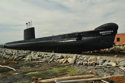 Historic shipHMCS Onondaga200 m away
 CathedralSaint-Germain Cathedral8.6 km away4
 MuseumMaison Lamontagne4.2 km away5
 MuseumMusée de Rimouski8.7 km away6Theme parkTheme parkL'Île des Moussaillons7.3 km away7MuseumMuseumPointe-Au-Père Lighthouse National Historic Site100 m away8MuseumMuseumMusée Des Soeurs De Notre-Dame Du St-Rosaire8.3 km away
Within 15 km, close and well known first. Numbers match the map.
Before visiting Light Tower
Where is Light Tower?
In Rimouski, Quebec, inside the town’s municipal boundary, is where Light Tower stands.
What is Light Tower?
National historic site.
Who runs Light Tower?
Parks Canada.
When is the best time to visit Light Tower?
Visit Rimouski from June to September for the warmest weather: highs of 18–24°C on the 1991–2020 normals.
Is Light Tower a designated historic place?
Yes: Classified Federal Heritage Building.
Sources: © OpenStreetMap contributors (ODbL), Wikidata (CC0), Statistics Canada’s ODCAF (Open Government Licence – Canada), the federal and Québec heritage registers, Statistics Canada 2021 census boundaries, ECCC 1991–2020 climate normals (Open Government Licence – Canada).
Photos: each place’s Wikidata image, from Wikimedia Commons under the licence below (our copy, resized).
Photo credits (6)
- Light Tower: Dennis G. Jarvis, CC BY-SA 2.0, Wikimedia Commons
- Site historique maritime de la Pointe-au-Père: Composition par Orbitale - Auteurs des photographies se retrouvant sur Wikimedia Commons : Supérieur gauche : Image:Onondaga musée.jpg par Alcide55 Inférieur gauche : Image:Empress of Ireland museum 2, CC BY-SA 3.0, Wikimedia Commons
- HMCS Onondaga: Letartean, CC BY 3.0, Wikimedia Commons
- Saint-Germain Cathedral: JF Lepage, CC BY-SA 3.0, Wikimedia Commons
- Maison Lamontagne: ChristianT, CC BY-SA 3.0, Wikimedia Commons
- Musée de Rimouski: ChristianT, CC BY-SA 3.0, Wikimedia Commons
Adapted from Statistics Canada (Census of Population 2021, population estimates 2025, 2021 census boundaries) under the Statistics Canada Open Licence; this does not constitute an endorsement by Statistics Canada. Neighbourhood names in some cities © OpenStreetMap contributors (ODbL).