Point Prim Lighthouse
Visitors to Charlottetown can see Point Prim Lighthouse, a museum. Add any of 7 more places within 5 km to a visit. Our list goes on with St. Dunstan's Roman Catholic Basilica, 4.6 km away.
Museum in Charlottetown
Inside Charlottetown
Point Prim Lighthouse is inside Charlottetown’s municipal boundary. Towns near it ↓
Drawn from OpenStreetMap, Wikidata, ODCAF and the heritage registers, with Statistics Canada’s 2021 outlines and ECCC’s 1991–2020 normals.
A month-by-month guide
For warmth, aim for June to September (19–24°C highs in Charlottetown).
Point Prim Lighthouse
In Charlottetown, inside the town’s municipal boundary.
- Type
- Museum
- Town
- in Charlottetown
Before you set off
Locating Point Prim Lighthouse
Orange: Point Prim Lighthouse.
© OpenStreetMap contributors · Numbers: the places near it, as listed below. The dashed line is Charlottetown’s municipal boundary. · Statistics Canada 2021 outline
Towns that list Point Prim Lighthouse
Charlottetown is the biggest of the 8 bases nearby (48,118 people). Pick a base: each town is a page of its own, with what else there is to see.
Charlottetown
Cornwall
Miltonvale Park
Stratford
Compare the 8 towns
| Town | Where Point Prim Lighthouse is | People | Places to visit |
|---|---|---|---|
| Charlottetown | It’s in town | 48,118 | 12 |
| Cornwall | 1.3 km south of it | 7,920 | 11 |
| Miltonvale Park | 2.6 km northwest of it | 1,279 | 3 |
| Stratford | 7.7 km east of it | 13,152 | 9 |
| Kingston | 10 km west of it | 1,308 | 1 |
| Crossroads | 12 km east of it | 2,366 | 7 |
| North Shore | 12 km northeast of it | 1,609 | 1 |
| West River | 14 km south of it | 4,155 | 8 |
Make a day of it near Point Prim Lighthouse
Around it, within 15 km, lie 11 more, including 4 museums, a church and a cathedral.
 ChurchSt. Dunstan's Roman Catholic Basilica4.6 km away2
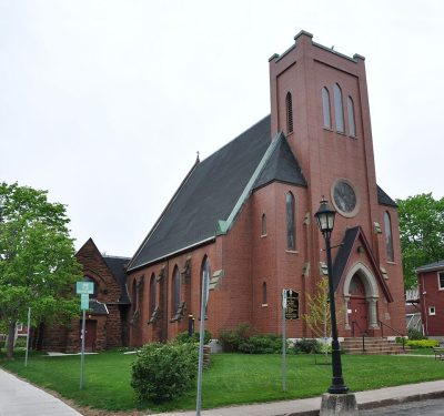 CathedralSt. Peter's Cathedral4.1 km away3
 Art galleryConfederation Centre Art Gallery4.4 km away4MuseumMuseumCOWS Creamery900 m away5
 FortSkmaqn–Port-la-Joye–Fort Amherst7.6 km away6MuseumMuseumBeaconsfield Historic House4.3 km away7MuseumMuseumPEI Museum & Heritage Foundation4.2 km away8MuseumMuseumThe Prince Edward Island Regiment Museum4.7 km away
Within 15 km, close and well known first. Numbers match the map.
What people ask about Point Prim Lighthouse
Where is Point Prim Lighthouse?
Look in Charlottetown, Prince Edward Island; Point Prim Lighthouse is within the municipal boundary.
What is Point Prim Lighthouse?
Museum.
When is the best time to visit Point Prim Lighthouse?
Afternoons in Charlottetown peak at 19–24°C from June to September (ECCC 1991–2020 normals).
Sources: © OpenStreetMap contributors (ODbL), Wikidata (CC0), Statistics Canada’s ODCAF (Open Government Licence – Canada), the federal and Québec heritage registers, Statistics Canada 2021 census boundaries, ECCC 1991–2020 climate normals (Open Government Licence – Canada).
Photos: each place’s Wikidata image, from Wikimedia Commons under the licence below (our copy, resized).
Photo credits (4)
- St. Dunstan's Roman Catholic Basilica: SoftwareSimian (changes by Rabanus Flavus ), CC BY-SA 4.0, Wikimedia Commons
- St. Peter's Cathedral: Robert Cutts from Bristol, England, UK, CC BY-SA 2.0, Wikimedia Commons
- Confederation Centre Art Gallery: Larry from Charlottetown, PEI, Canada, CC BY 2.0, Wikimedia Commons
- Skmaqn–Port-la-Joye–Fort Amherst: MTLskyline, CC BY-SA 3.0, Wikimedia Commons
Adapted from Statistics Canada (Census of Population 2021, population estimates 2025, 2021 census boundaries) under the Statistics Canada Open Licence; this does not constitute an endorsement by Statistics Canada. Neighbourhood names in some cities © OpenStreetMap contributors (ODbL).