
Chiefswood
Highway 54, Six Nations (Part) 40
Chiefswood, c. 1900 and today
Drag across to compare. The two views aren’t taken from exactly the same spot.

c. 1900: Public domain. Today: Photo: Steve Colwill from Ottawa, Canada · CC BY 2.0.
About Chiefswood
Chiefswood is one of 2 National Historic Sites in Six Nations (Part) 40. Construction of Chiefswood is recorded as 1853–1857.
Chiefswood is a small gem of an Italianate villa set in a picturesque treed landscape on the banks of the Grand River in the heart of the Six Nations Grand River Territory, in Ontario. Its location is key to its historic meaning as the home of the Johnson family, especially poet E. Pauline Johnson. The formal recognition refers to the interior and exterior of the house.
From the Canadian Register of Historic Places, Chiefswood National Historic Site of Canada · Open Government Licence – Canada · the register’s own words, unchanged
The Historic Sites and Monuments Board recommends National Historic Sites; the designation marks national significance, not ownership.
2 old views of Chiefswood
Made before 1950, from 1900 to 1929: public domain or CC0. Tap one to see it full screen.
c. 1900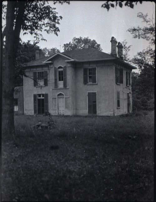 c. 1929
From Wikimedia Commons, copied to our own server; some are drawings, prints or maps of their time. Each credit is in the viewer.
Finding Chiefswood
Six Nations (Part) 40


It stands apart from the town’s other historic places.
Questions about Chiefswood
Is Chiefswood protected?
National Historic Site status commemorates; legal protection, where there is any, comes from the province or municipality, or from federal ownership.
Can you visit Chiefswood?
Yes, most likely: it is recorded as a museum, though hours vary.
What is Chiefswood?
Chiefswood has been a National Historic Site of Canada since 1953.
When was Chiefswood built?
The record of Chiefswood gives 1853–1857.
Contains information licensed under the Open Government Licence – Canada (Parks Canada).
Sources: Parks Canada, Directory of Federal Heritage Designations · Canadian Register of Historic Places (federal extract) · Photos: Wikimedia Commons, each credited with its licence and copied to our own server · Wikidata (CC0) for map points, other names and articles.
Adapted from Statistics Canada (Census of Population 2021, population estimates 2025, 2021 census boundaries) under the Statistics Canada Open Licence; this does not constitute an endorsement by Statistics Canada. Neighbourhood names in some cities © OpenStreetMap contributors (ODbL).