Lower Battery
Lower Battery, a national historic site, stands in Schmidtville. Nearby, 11 more places to visit are within 5 km. It counts as a Classified Federal Heritage Building.
National historic site in Schmidtville
Inside Schmidtville
Inside Schmidtville’s neighbourhood outline: Lower Battery. Towns near it ↓
Cared for by Parks Canada
One of the places Parks Canada looks after; members usually get in free. About ↓
Classified Federal Heritage Building
It holds a federal or Québec heritage designation, or sits on the Canadian Register of Historic Places. About ↓
Drawn from OpenStreetMap, Wikidata, ODCAF and the heritage registers, with Statistics Canada’s 2021 outlines and ECCC’s 1991–2020 normals.
Weather by the month
In Schmidtville, June to September bring the warmest days: highs of 19–23°C.
Lower Battery
The site is kept up by Parks Canada. Around it, Georges Island (100 m) comes first on our list.
- Type
- National historic site
- Run by
- Parks Canada
- Listed
- Classified Federal Heritage Building
- Town
- in Schmidtville
Mapping Lower Battery
Orange is Lower Battery; numbered in green, the places near it.
© OpenStreetMap contributors · The dashed line is Schmidtville’s neighbourhood outline. · Statistics Canada 2021 outline
Towns that count Lower Battery
Largest of the 8 is Austinville, home to 28,021. Pick a base: each town is a page of its own, with what else there is to see.
Schmidtville
South End
Manor Park
Portland Estates
Compare the 8 towns
| Town | Where Lower Battery is | People | Places to visit |
|---|---|---|---|
| Schmidtville | It’s in town | 18,105 | 44 |
| South End | 600 m southwest of it | 22,012 | 44 |
| Manor Park | 1.1 km north of it | 14,148 | 46 |
| Portland Estates | 1.5 km northeast of it | 10,164 | 46 |
| North End | 2.2 km west of it | 19,733 | 40 |
| Eastern Passage | 2.2 km east of it | 10,745 | 41 |
| Austinville | 2.5 km northwest of it | 28,021 | 45 |
| Westmount | 2.9 km southwest of it | 23,207 | 41 |
Close to Lower Battery
Our list has 11 more within 15 km, among them 3 museums, 2 historic ships and a fort.
 FortGeorges Island100 m away2
 ChurchSt. Mary's Basilica1.3 km away
 Historic shipHMCS Sackville1.2 km away
 Art galleryArt Gallery of Nova Scotia1.5 km away5
 MuseumMaritime Museum of the Atlantic1.3 km away6
 MuseumCanadian Museum of Immigration at Pier 21600 m away7
 MuseumDiscovery Centre800 m away
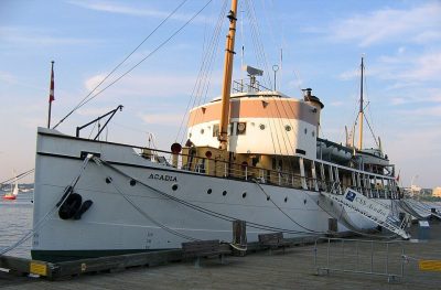 Historic shipS.S. Acadia1.2 km away
Within 15 km, close and well known first. Numbers match the map.
A visit to Lower Battery: questions
Where is Lower Battery?
Lower Battery is in Schmidtville, Nova Scotia, inside the town’s neighbourhood outline.
What is Lower Battery?
National historic site.
Who runs Lower Battery?
Parks Canada.
When is the best time to visit Lower Battery?
Afternoons in Schmidtville peak at 19–23°C from June to September (ECCC 1991–2020 normals).
Is Lower Battery a designated historic place?
Yes: Classified Federal Heritage Building.
Sources: © OpenStreetMap contributors (ODbL), Wikidata (CC0), Statistics Canada’s ODCAF (Open Government Licence – Canada), the federal and Québec heritage registers, Statistics Canada 2021 census boundaries, ECCC 1991–2020 climate normals (Open Government Licence – Canada).
Photos: each place’s Wikidata image, from Wikimedia Commons under the licence below (our copy, resized).
Photo credits (8)
- Georges Island: Thparkth, CC BY-SA 3.0, Wikimedia Commons
- St. Mary's Basilica: baekken, CC BY 2.0, Wikimedia Commons
- HMCS Sackville: Bryson109 at English Wikipedia, Public domain, Wikimedia Commons
- Art Gallery of Nova Scotia: Skeezix1000, CC BY-SA 3.0, Wikimedia Commons
- Maritime Museum of the Atlantic: Letterofmarque, CC BY 3.0, Wikimedia Commons
- Canadian Museum of Immigration at Pier 21: Skeezix1000, CC BY-SA 3.0, Wikimedia Commons
- Discovery Centre: Ben MacLeod, CC BY-SA 4.0, Wikimedia Commons
- S.S. Acadia: Robert Alfers, Public domain, Wikimedia Commons
Adapted from Statistics Canada (Census of Population 2021, population estimates 2025, 2021 census boundaries) under the Statistics Canada Open Licence; this does not constitute an endorsement by Statistics Canada. Neighbourhood names in some cities © OpenStreetMap contributors (ODbL).