
Prim Point Lighthouse
In French: Phare de Point Prim
Lighthouse Road, Digby
Prim Point Lighthouse, 1874 and today
Drag across to compare. The two views aren’t taken from exactly the same spot.
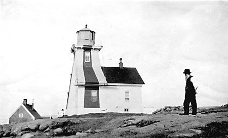
1874: Photo: Nova Scotia Archives · Public domain. Today: Photo: Dennis G. Jarvis · CC BY-SA 2.0.
About Prim Point Lighthouse
Prim Point Lighthouse is one of 3 heritage lighthouses in Digby. Construction of Prim Point Lighthouse is recorded as 1964.
The Prim Point Lighthouse is a 13.9 metres (46 feet) tall reinforced-concrete tower with an attached fog alarm building. Built in 1964, it is the third tower on this site to mark the narrow passage at Digby Gut. It sits in a wooded area overlooking the rocky cliffs on the west point of Digby Gut at the narrow opening of the Annapolis Basin in the Bay of Fundy.
From the Canadian Register of Historic Places, Prim Point Lighthouse · Open Government Licence – Canada · quoted as the register has it
Heritage lighthouses were designated under federal law from 2008.
1 old view of Prim Point Lighthouse
Made before 1950, from 1874: public domain or CC0. Tap one to see it full screen.
1874From Wikimedia Commons, copied to our own server; some are drawings, prints or maps of their time. Each credit is in the viewer.
Finding Prim Point Lighthouse
Digby


There is no walk from here to another historic place; see farther afield.
Questions about Prim Point Lighthouse
Can you visit Prim Point Lighthouse?
From outside, yes; going in depends on who owns or runs it.
Is Prim Point Lighthouse protected?
Yes: the Heritage Lighthouse Protection Act limits changes to it.
What is Prim Point Lighthouse?
Prim Point Lighthouse: a heritage lighthouse, designated in 2015.
When was Prim Point Lighthouse built?
By its record, Prim Point Lighthouse dates from 1964.
Contains information licensed under the Open Government Licence – Canada (Parks Canada).
Sources: Parks Canada, Directory of Federal Heritage Designations · Canadian Register of Historic Places (federal extract) · Photos: Wikimedia Commons, each credited with its licence and copied to our own server · Wikidata (CC0) for map points, other names and articles.
Adapted from Statistics Canada (Census of Population 2021, population estimates 2025, 2021 census boundaries) under the Statistics Canada Open Licence; this does not constitute an endorsement by Statistics Canada. Neighbourhood names in some cities © OpenStreetMap contributors (ODbL).