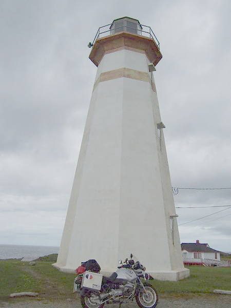
Cape Ray Light Tower
In French: Phare de Cape Ray
Access road off Route 408, Division No. 4, Subdivision A
About Cape Ray Light Tower
The federal government recognizes Cape Ray Light Tower for its heritage, one of 2 such buildings in Division No. 4, Subdivision A. Cape Ray Light Tower dates from 1959–1961. The register names Department of Transportation as its architect.
The Cape Ray heritage lighthouse consists of a freestanding, reinforced-concrete, tapered octagonal tower surmounted by an aluminum and glass lantern. Situated near a small fishing village by the same name, in an isolated area on the southwest coast of Newfoundland, the lighthouse guides international and coastal shipping vessels navigating the Cabot Strait, where the Atlantic Ocean intersects with the Gulf of St. Lawrence. There are two related building on the site that contribute to the heritage character of the lighthouse: (1) the 1990 office and (2) the 2001 fog alarm building.
From the Canadian Register of Historic Places, Cape Ray Light Tower · Open Government Licence – Canada · as published, word for word
Federal heritage buildings are Classified or Recognized; this one is Recognized.
Finding Cape Ray Light Tower
Division No. 4, Subdivision A


It stands apart from the town’s other historic places.
Questions about Cape Ray Light Tower
Is Cape Ray Light Tower protected?
While the federal government owns it, changes go through its heritage review.
Can you visit Cape Ray Light Tower?
It can be seen from the street; whether you can go inside depends on its owner.
When was Cape Ray Light Tower built?
Cape Ray Light Tower went up in 1959–1961, by its record.
What is Cape Ray Light Tower?
Cape Ray Light Tower: a federal heritage building, Recognized in 2007.
Contains information licensed under the Open Government Licence – Canada (Parks Canada).
Sources: Parks Canada, Directory of Federal Heritage Designations · Canadian Register of Historic Places (federal extract) · Photos: Wikimedia Commons, each credited with its licence and copied to our own server · Wikidata (CC0) for map points, other names and articles.
Adapted from Statistics Canada (Census of Population 2021, population estimates 2025, 2021 census boundaries) under the Statistics Canada Open Licence; this does not constitute an endorsement by Statistics Canada. Neighbourhood names in some cities © OpenStreetMap contributors (ODbL).