
Rotary Park
Rotary Park is an urban park. Head into Crescent Heights’ neighbourhood outline to find it. Further out, Glenbow Museum is 1.3 km away.
Garden in Crescent Heights
Inside Crescent Heights
You’ll find Rotary Park inside Crescent Heights’ neighbourhood outline. Towns near it ↓
Drawn from OpenStreetMap, Wikidata, ODCAF and the heritage registers, with Statistics Canada’s 2021 outlines and ECCC’s 1991–2020 normals.
A month-by-month guide
From June to September, Crescent Heights sees highs of 18–24°C.
Rotary Park
Wikipedia covers it in 2 languages.
- Type
- Garden
- Wikipedias
- Covered in 2 languages
- Town
- in Crescent Heights
- Official site
- calgary.ca/parks/rotary-park.html
Getting your bearings
Use the numbers to match each place near Rotary Park with the list.
© OpenStreetMap contributors · The dashed line is Crescent Heights’ neighbourhood outline. · Statistics Canada 2021 outline
Towns around Rotary Park, by distance
In size, Downtown Commercial Core comes first of the 8, with 9,286 people. These are the towns that list it, beginning with its own.
- 1Crescent Heights
- 2Sunnyside
- 3Eau Claire
- 4Downtown Commercial Core
- 5Renfrew
- 6Bridgeland/Riverside
- 7Rosedale
- 8Downtown East Village
Crescent Heights
Sunnyside
Eau Claire
Downtown Commercial Core
Compare the 8 towns
| Town | Where Rotary Park is | People | Places to visit |
|---|---|---|---|
| Crescent Heights | It’s in town | 6,411 | 39 |
| Sunnyside | 300 m west of it | 2,976 | 43 |
| Eau Claire | 400 m west of it | 3,733 | 44 |
| Downtown Commercial Core | 500 m west of it | 9,286 | 45 |
| Renfrew | 500 m east of it | 6,685 | 38 |
| Bridgeland/Riverside | 500 m southeast of it | 6,860 | 38 |
| Rosedale | 800 m northwest of it | 2,507 | 32 |
| Downtown East Village | 900 m south of it | 3,524 | 35 |
More to see nearby
The places within 15 km include 3 museums, 3 gardens and an attraction.
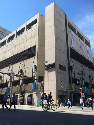 MuseumGlenbow Museum1.3 km away · 149K visitors a year (2019)2
 AttractionCalgary Tower1.4 km away3
 GardenPrince's Island Park700 m away4
 MuseumFort Calgary1.8 km away5
 GardenOlympic Plaza1.2 km away6
 MuseumCalgary Chinese Cultural Centre700 m away7
 CathedralCathedral Church of the Redeemer1.1 km away8
 GardenDevonian Gardens1.4 km away
Within 15 km, close and well known first. Numbers match the map.
Rotary Park: what to know
Where is Rotary Park?
Rotary Park is in Crescent Heights, Alberta, inside the town’s neighbourhood outline.
What is Rotary Park?
Urban park in Calgary, Alberta, Canada.
How well known is Rotary Park?
On our list for Canada, Rotary Park comes #741 by how widely it is covered.
When is the best time to visit Rotary Park?
Warmth peaks in Crescent Heights from June to September, when afternoons reach 18–24°C (ECCC normals, 1991–2020).
Sources: © OpenStreetMap contributors (ODbL), Wikidata (CC0), Statistics Canada’s ODCAF (Open Government Licence – Canada), the federal and Québec heritage registers, Statistics Canada 2021 census boundaries, ECCC 1991–2020 climate normals (Open Government Licence – Canada).
Photos: each place’s Wikidata image, from Wikimedia Commons under the licence below (our copy, resized).
Photo credits (9)
- Rotary Park: Grungaloo, CC BY-SA 4.0, Wikimedia Commons
- Glenbow Museum: Darthrussel, CC BY-SA 4.0, Wikimedia Commons
- Calgary Tower: Qyd, CC BY 2.5, Wikimedia Commons
- Prince's Island Park: Scott5114, Public domain, Wikimedia Commons
- Fort Calgary: Thivierr, CC BY-SA 3.0, Wikimedia Commons
- Olympic Plaza: Resolute, CC BY-SA 3.0, Wikimedia Commons
- Calgary Chinese Cultural Centre: Greenwood714, CC BY-SA 3.0, Wikimedia Commons
- Cathedral Church of the Redeemer: Dbraw, CC BY-SA 3.0, Wikimedia Commons
- Devonian Gardens: Qyd, CC BY 2.5, Wikimedia Commons
Adapted from Statistics Canada (Census of Population 2021, population estimates 2025, 2021 census boundaries) under the Statistics Canada Open Licence; this does not constitute an endorsement by Statistics Canada. Neighbourhood names in some cities © OpenStreetMap contributors (ODbL).