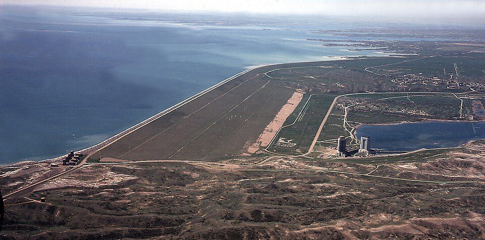
Fort Peck Dam
The Fort Peck Dam is the highest of six major dams along the Missouri River, located in northeast Montana in the United States, near Glasgow, and adjacent to the community of Fort Peck.

A dam, 36 mi west of Wolf Point
Winters are cold
January nights drop to 3°. When to go ↓
Plan where you’ll sleep
No town within 30 miles has many hotels or campgrounds. Look at the towns below, or plan to camp. Where to stay ↓
Best months: May, Jun and Sep
May, June and September are the mild months, with highs of 69–78°. When to go ↓
Established in 1933
Fort Peck Dam dates from 1933. About ↓
Written from NOAA 1991–2020 normals, Overture places to stay, Census town figures, Wikidata and Wikipedia.
Weather, month by month
Typical highs and lows in Wolf Point. Green months are the mild ones.
Fort Peck Dam
The Fort Peck Dam is the highest of six major dams along the Missouri River, located in northeast Montana in the United States, near Glasgow, and adjacent to the community of Fort Peck. At 21,026 feet (6,409 m) in length and over 250 feet (76 m) in height, it is the largest hydraulically filled dam in the United States, and creates Fort Peck Lake, the fifth largest artificial lake in the U.S., more than 130 miles (210 km) long, 200 feet (61 m) deep, and it has a 1,520-mile (2,450 km) shoreline which is longer than the state of California's coastline. It lies within the Charles M. Russell National Wildlife Refuge. The dam and the 134-mile-long (216 km) lake are owned and operated by the U.S. Army Corps of Engineers and exist for the purposes of hydroelectric power generation, flood control, and water quality management.
- Type
- Dam
- Established
- 1933
- Listed
- National Register of Historic Places (1986) · Historic Civil Engineering Landmark
- Wikipedia readers
- 26K a year
Where to stay near Fort Peck Dam
Towns within 30 miles, best bases first.
Wolf Point
The closest town with somewhere to stay.
2,531 people
36 mi east of Fort Peck Dam
Compare 3 towns
| Town | From Fort Peck Dam | Drive | Places to stay | People | Typical home | Safety |
|---|---|---|---|---|---|---|
| Wolf Point | 36 mi east | 55 min | 2 2 inns & B&Bs | 2,531 | $119K | C− |
| Circle | 56 mi southeast | 1.5 hr | 1 1 motel | 590 | $172K | — |
| Poplar | 57 mi east | 1.5 hr | 1 1 hotel | 722 | $95K | — |
Getting there
Nearest airports with airline service
Visiting Fort Peck Dam
What town is Fort Peck Dam near?
Wolf Point, MT, about 36 miles east.
When is the best time to visit Fort Peck Dam?
May, June and September, with highs of 69–78°.
What is the closest airport to Fort Peck Dam?
Glasgow Valley County Airport Wokal Field (GGW), about 17 miles away.
Tips from people in Wolf Point
No tips yet. Ask, or answer, in Wolf Point’s Town Square.
Sources: National Park Service · ski areas © OpenSkiMap / OpenStreetMap contributors · Wikidata · Wikipedia readership · NOAA climate normals · U.S. Census.